
This is part 7 of a series. See also Introduction • Historical Background • Latter Half of the 20th Century • Neighborhood Walking • Neighborhood Crime • Vehicle Miles and Traffic
High-connectivity thoroughfare patterns are the foundation of walkable neighborhoods and districts. While that fact was self-evident for most of human history, it was lost or ignored by land development and transportation professionals in the post-WWII era. Today, even as the numerous benefits of high connectivity are becoming increasingly recognized, the auto-centric standards of yesteryear remain firmly dominant, particularly in the field of traffic engineering.
Traffic engineering standards discourage small blocks and frequent intersections because of safety concerns. Many jurisdictions have codified those standards into their planning regulations for suburban construction, with the result that most new development consists of isolated pods depending from highway-size arterials. It is a profoundly auto-oriented pattern that is hostile to pedestrians and bicyclists. It creates the typical suburban landscape of separated, isolated pockets instead of the continuous fabric of streets and blocks that is characteristic of efficient, walkable towns and cities.
Are the safety objections against high connectivity grounded in reality? Several investigations suggest that the position promulgated by mainstream traffic engineering standards can be legitimately questioned. Because this is a new and somewhat revolutionary avenue of thought, formal statistical support is just beginning to be compiled. The initial round of studies has found that livable, walkable neighborhoods with well-connected streets are no less safe, and in some respects are safer, than the standard suburban template.
Terms of art
A discussion of traffic engineering and connectivity standards needs to begin with an understanding of two traffic engineering concepts. One is access management. The other is functional classification.
1. Regulations that limit connectivity are based on access management principles. The Transportation Research Board gives these definitions of access management:
Access Management seeks to limit and consolidate access along major roadways, while promoting a supporting street system and unified access and circulation systems for development. The result is a roadway that functions safely and efficiently for its useful life, and a more attractive corridor.
Access management is much more than driveway regulation. It is the systematic control of the location, spacing, design and operation of driveways, median openings, interchanges, and street connections. It also encompasses roadway design treatments such as medians and auxiliary lanes, and the appropriate spacing of traffic signals.
In his history of access management, Demosthenes (1999) outlines how access management for highways became ubiquitous in the late 1930s and early 1940s. As rural roads developed into highways, commercial strips became the preferred form of commerce. Every business on the strip wanted its own driveway for fast and easy access. But slow-moving traffic accessing driveways to and from fast-moving highways was a recipe for disaster. The number of crashes shot up.
Access management began as an effort to limit the number of driveways opening on to highways and arterials. It is beneficial in that specific application. But since the 1980s it has experienced a form of mission creep, adopting a single-minded determination to limit intersections everywhere, in all contexts. Access management limits connectivity for walkable developments with little regard for empirical evidence or context.
2. Traffic engineering theory links access management with roadway categories to create a unified system called functional classification. In its simplest sense, functional classification works like this: The bigger and faster the roadway, the less access is allowed. The total focus and goal of functional classification is fast, free-flowing movement of automobiles.

The standard illustration of functional classification. Image credit: FHWA
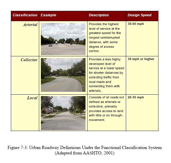
Table of functional classification definitions. Image credit: Eric Dumbaugh
Functional classification in the U.S. recognizes only three types of roads: arterial, collector and local. Each of these types can be either rural or urban, making six categories total. The result is a dumbed-down understanding of thoroughfares that is incapable of dealing with walkable, livable streets. Functional classification does not recognize the rich diversity of livable thoroughfare types, such as mews, lanes, woonerven, high streets, main streets, avenues, and boulevards.
Standards that promote low connectivity
The Transportation Research Board’s Access Management Manual is the primary reference for engineers and planners. It was revised in 2003, and so it responds to some of the recent findings about the benefits of connectivity. However, the approach of the Manual is bipolar. Using general, descriptive language it extols the benefits of connectivity for local and collector streets. It recommends a flexible planning policy. Then, using extensively detailed numbers, tables and charts, the Manual specifies low-connectivity, auto-oriented standards for arterials.
The Manual’s bipolar approach is exemplified in this passage:
As communities grow and land is subdivided for development, it is important to promote continuation and extension of the existing local street system. Dead-end streets, cul-de-sacs, and gated communities force more traffic to use major roadways even for short local trips. Fragmented street systems also impede emergency access and increase the length of automobile trips.
Providing alternative routes for short, local trips helps to reduce traffic demand on major roadways. Other benefits may include fewer vehicle miles traveled; improved accessibility of developed areas; fewer access problems on major roadways; and greater opportunities for walking, bicycling and transit use.
A caveat relates to the connection of minor local streets to roadways of a high functional classification. In these instances, it is important to minimize the the number of street connections to avoid creating too many conflicts on the major roadway.
— Access Management Manual, pp. 103-104
The result is residential subdivisions that are surrounded by highway-size streets and freeway-speed traffic. This pattern, hostile and dangerous for pedestrians and bicyclists, has become ubiquitous in U.S. suburban construction.
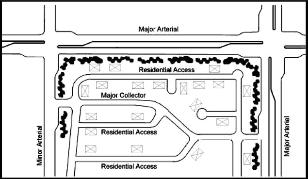
Typical suburban roadway pattern
If you’ve spent time in a U.S. suburb built within the past 30 years, this template will probably be very familiar to you. It’s the same in many parts of the country, and it’s one reason our built environment is becoming more homogenized and generic.
Having discharged its nominal obligation to high connectivity, the Manual moves on to its main topic of concern: removing impediments to fast traffic on large roadways. Unlike the Manual’s few paragraphs about high connectivity, the “Access Spacing” chapter is highly detailed and specific. Numerous studies are cited; an abundance of tables and charts provide highly specific numerical data; and detailed diagrams illustrate the principles. The main reasons given for restricting intersections (also called “conflict areas”) on arterials are fast, uninterrupted traffic and lower crash rates.
Each new access point introduces conflicts and friction into the traffic stream. With more conflicts comes a higher potential for crashes, and the resulting friction translates into longer travel times and greater delay. To address these issues, access management programs establish minimum requirements for access spacing. … (p. 143)
The separation of conflict areas allows drivers to respond to a series of situations, instead of having to react to a complex pattern of overlapping conflicts. This simplifies the driving task and reduces the likelihood of driver mistakes that lead to collisions. Ideally, the separation of conflict areas will allow drivers to consider them one at a time. This distance is a function of perception-reaction time and increases with speed. … (p. 144)
Separation of conflict areas has long been recognized as an effective way to improve vehicular safety as well as pedestrian and bicycle safety. Table 9-4 shows that crashes can be expected to increase as access connection spacing decreases. For example, the crash rate for access connections spaced at an average interval of 261 ft can be expected to be 2.1 times that for an average spacing of 1,056 ft. … (p. 150)
The Access Management Manual recommends that signalized intersections be spaced 1/2 mile (2,640 ft) apart on arterials. T-intersections on major arterials should be spaced 1/4 mile (1,320 ft) apart. The Manual draws upon and incorporates other major studies and guidebooks, such as Impacts of Access Management Techniques by Gluck et al. These guidebooks, as well as many state regulations, specify similar dimensions.
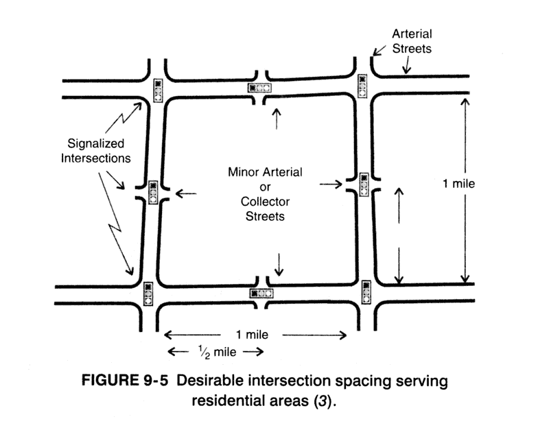
Recommended intersection spacing on arterials. Image credit: TRB Access Management Manual
How does this compare to block sizes in walkable neighborhoods? A review of the best block sizes for walkable neighborhoods was made by this author for the TND Design Rating Standards. A wide range of sources was consulted, including Great Streets by Allan Jacobs, Planning for Street Connectivity by Handy et al., various municipal ordinances, and direct evidence from historic neighborhoods and towns in the U.S. The following guidelines were developed.
Block length (in feet)
Excellent: 250-400
Good: 200-250 or 400-500
Acceptable: 500-600
Fair: 150-200 or 600-800
Poor: Less than 150 or more than 800In car-free or car-restricted areas, smaller block sizes are more viable and should not be given low ratings.
—TND Design Rating Standards, Version 1.5 (2005)
Note that most traffic engineering manuals do in fact specify shorter access spacing under certain conditions. The Access Management Manual recommends that nonsignalized intersections on minor arterials be spaced 660 feet apart; nonsignalized T-intersections on minor arterials should be spaced 330 feet apart. However, these references are mostly about driveways. It is generally assumed that access to arterials will be via a) driveways or b) signalized intersections. When intersection traffic is greater than a certain volume, the manuals call for intersections to be signalized. And signalized intersections must be spaced 1/4 to 1/2 mile apart.
What’s an engineer to do? When faced with potentially conflicting advice, competing demands, and lack of knowledge about legal ramifications, engineers try to be responsible. They will make the most conservative interpretations in order to minimize the possibility of legal liability and accusations of malpractice. The takeaway message of access management: Small blocks and well-connected streets are forbidden near major thoroughfares.
Developers follow the bandwagon because of insurance and financing expectations. It is usually too time-consuming and expensive to buck the engineering departments, city hall, or state government.
The official position of the American Planning Association supports high connectivity for walkable urban design. Even so, leading and mainstream planners support restricted connectivity on major roadways. A letter to the Journal of the American Planning Association illustrates a prevailing attitude — that access management equals safety across the board.
The authors appear to suggest that poor external connectivity (measured as the median distance between access points) is contributing to sprawl to the detriment of the region. I assume from the definition that the authors are referring to access spacing on major roadways. However, major roadways are precisely what connects communities and activity centers. Managing access to those roadways is critical to preserving the safety and mobility of those who travel in the region. Numerous studies have shown that crash rates on major roadways rise as access density increases. …
Less “external connectivity” on the major roadway system helps connect a region, and this combined with improved “internal connectivity” is a desirable outcome of the region’s access management policies, not a detriment or contributor to sprawl.
— Letters to the Editor, JAPA, Autumn 2004, p. 481.
Safety first?
The evidence on connectivity and safety is based on decades of research that covers hundreds of roadway segments in the U.S. All report conclusions point in the same direction. The evidence seems irrefutable.
Until recently, advocates of walkable, well-connected streets simply accepted the research and argued that it was worth trading some safety for a better built environment. As you might imagine, that line of argument has been unpersuasive in most cases. As a result, the most common flaw in new walkable developments has been their lack of external connectivity. They are usually bounded by high speed arterials just like conventional subdivisions.
Recently, however, the engineering research data about crash safety has been challenged.
In his groundbreaking dissertation Safe Streets, Livable Streets: A Positive Approach to Urban Roadside Design (2005), Eric Dumbaugh makes this basic point: Crash safety research never takes context into account. In Dumbaugh’s perspective, context is essential to crash safety theory. Context is critical in thoroughfare design practice and has a major effect on empirical, real-world crash safety results.
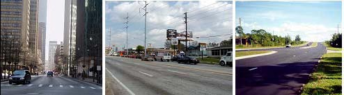
Photos by Eric Dumbaugh
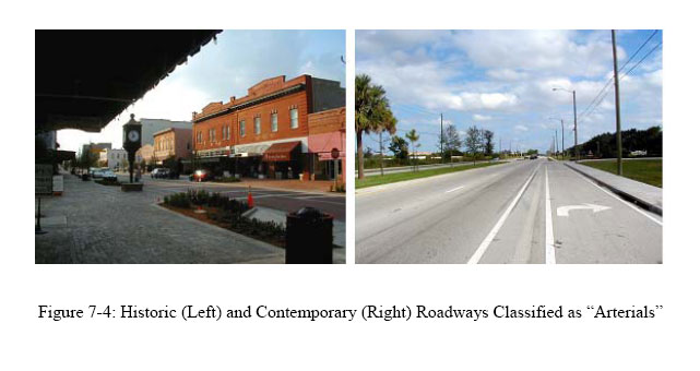
Consider the three thoroughfares pictured above. All three have an identical classification. According to traffic engineering standards, all three are minor arterials in urban areas. Yet, as anyone with common sense can see, the contexts are extremely different, representing vastly different understandings of “urban” and “arterial.” Due to the dumbed-down, reductionist practice of functional classification, these three thoroughfares share the same overly broad, overly vague designation.
This means that research results are lumped together. Crash safety data from unwalkable exurban roadways, for example, are lumped together with data from intensely walkable urban avenues. It’s all the same in the perspective of traffic engineering theory. But when context is factored in, the data support very different conclusions.
Passive safety vs. livable streets
Much of Dumbaugh’s investigation is focused on “livable streets.” Dumbaugh defines livable streets:
… livable streets, at a minimum, seek to enhance the pedestrian character of the street by both increasing its aesthetic appeal
, as well as minimizing the negative impacts of automobile use on pedestrians. Of particular importance is the design of the roadside, which is the area between the vehicle travelway and edge of the right-of-way. In urban areas, the roadside is the location for most of the activities that characterize urban living, and often include sidewalks, benches, street cafes and indeed, most non-motorized activity. Correspondingly, livability advocates encourage the placement of street trees, landscaping, aesthetic street lights and other roadside features along the edge of the vehicle travelway to both increase a street’s aesthetic appeal, as well as to physically buffer pedestrians from potentially hazardous oncoming traffic.
— Safe Streets, Livable Streets, p. 3-4

Livable downtown streets. Photos by Eric Dumbaugh
Dumbaugh discusses in some detail the paradigm that controls thinking in the traffic engineering profession. Up until the 1950s, it was assumed that drivers could exercise their own judgment and respond with appropriate caution to tight corners, limited visibility, intersections, and other challenges. But that approach was replaced by a paradigm called “passive safety,” which was championed by Sen. Daniel Moynihan and Ralph Nader in the 1960s. Passive safety assumes that driver error is random and impossible to predict, removes human judgment from the equation, and treats safety in a similar manner as structural engineering.
Thus, just as a bridge that can bear a 60-ton load can also bear a 30-ton load, the passive safety perspective assumes that a roadway designed to be safe for 60 mph operating conditions is also safe for 30 mph operating conditions.
— Safe Streets, Livable Streets, p. 80
Passive safety calls for reducing all physical conditions that could conceivably be involved in traffic crashes. It means that anything drivers might crash into, like street trees, benches, parked cars and intersections, should be cleared away and minimized as much as possible. Guidelines based on the passive safety philosophy make livable streets difficult or impossible to construct.

Arterial built according to conventional safety standards, left, and a livable street, right. Photos by Eric Dumbaugh
Two arterials: livable street in historic, walkable context (left) and the contemporary version (right). Photos by Eric Dumbaugh
Dumbaugh combed through earlier studies to discover what the empirical evidence had to say about the crash safety of livable streets. The weight of the evidence suggested that livable streets were safer, particularly in urban environments. This, of course, contradicts all traffic engineering theory and is opposite to traffic engineering standards.
Dumbaugh points out that contrary evidence is often considered to be anomalous data, or “outliers,” and is removed from the statistical calculations. This pattern may also crop up in access management research; for example, Impacts of Access Management Techniques states on page 36: “The first step was to further screen [road] segments for characteristics or accident rates that did not appear to be consistent with the rest of the data. … After the potential ‘outliers’ were removed from the database, frequency distributions and cross-classifications were performed to identify potential strata and to explore relationships.”
The culprit is speed
Dumbaugh performed a study of crashes on arterials and livable streets in Central Florida. He examined two types of roadside crashes: crashes with fixed objects (including those occurring at intersections), and midblock (not at intersections) crashes, including crashes that involved multiple vehicles or pedestrians. Dumbaugh found that livable streets were safer than urban streets as a whole. In fact, on the livable streets that he investigated, there were no injury-causing roadside crashes whatsoever.
As is readily evident, the livable sections are markedly safer than the urbanized portions of these roadways as a whole. Collectively, livable street sections reported 67% fewer total roadside crashes per vehicle mile traveled, and 100% fewer injurious roadside crashes. Comparing crashes per mile, the livable sections had 50% fewer total crashes, and 100% fewer injurious crashes.
In short, there can be no doubt that livable street treatments are safer than one would expect from baseline roadway averages, particularly for injurious crashes. Indeed, that not a single injurious roadside crash occurred on these roadways during the 5-year evaluation period is a profoundly important finding.
— Safe Streets, Livable Streets, p. 134
Dumbaugh found that most crashes with roadside fixed objects happened at intersections — but only suburban and rural intersections. The risk of all roadside crashes was much lower on livable streets. The reason is simple: reduced speed on livable streets. The higher arterial speeds that traffic engineering strives for so mightily are directly responsible for increased crash rates.
Yet one examining roadside crashes in urban environments cannot conclude that these crashes are simply the result of purely random and unpreventable errors on the part of the driver. Instead, there was a clearly discernible pattern to these crashes, a pattern that appears to be strongly influenced by a roadway’s design. Between 65-83% of all fixed-objects involved in a roadside crash are located behind a driveway or intersection, rather than at random locations located along the roadway. The behavioral pattern that seems to produce these crashes is that drivers are attempting to negotiate turns into driveways and intersections at the high speeds designed into the main arterial, a maneuver that causes them to leave the travelway at the back-end of the driveway or intersection. When an object is present at this location, a fixed-object crash occurs.
— Safe Streets, Livable Streets, p. 188-189
The key factor in crash risk is design speed. Design speed is the speed at which drivers feel comfortable traveling; it is an entirely different concept than posted speed limits, which drivers usually feel are safe to exceed. Thanks to context, slow speeds prevail on livable streets. Drivers drive more slowly because the context signals the type of activity, amount of activity, and potential hazards that can be expected. Drivers “read” the context of livable streets and are impelled to exercise more caution.
Conversely, idiot-proof roadsides foster the illusion of safety and encourage speeding and lack of attention. High speed plus a lack of caution increases crash risk.
Passive safety gained widespread acceptance in the U.S in 1966. That year, the United States had fewer traffic crash fatalities per capita than all other countries except Great Britain. Today, the U.S. has fallen behind the European Union, Australia, Japan and most of the developed world in per-capita traffic injuries and fatalities. One factor causing this is design standards and speed. The highest design speed recommended for an urban arterial in Europe is 30 mph. In the U.S. system, 30 mph is the minimum design speed recommended for an arterial, whether it be urban, suburban or rural.
And thus the problem with passive safety. Passive safety is a design paradigm derived from limited observations of Interstates and high-speed rural arterials, and has been subjected to very little empirical testing for its appropriateness in other design contexts. Yet, as currently embodied in design guidance, it is presumed to be a complete theory of roadway design, in spite of a growing body of contradicting empirical evidence. Common sense suggests that it is unreasonable to assume that design practices appropriate for high-speed roadways that exclude non-motorists and do not provide land access are also appropriate for all other roadway types. Nevertheless, contemporary roadside design practice is based on exactly this assumption.
— Safe Streets, Livable Streets, p. 185
Traffic crash reports from a variety of countries are furnishing evidence that more pedestrian-oriented intersections, cities and regions are safer. A 2002 study of 300 intersections in Ontario found that the greater the flow of pedestrians, the less risk of traffic crashes. The conclusion stated: “As risk decreases with increasing pedestrian flows, promoting walking will have a positive effect on pedestrian risk at signalized intersections.”
A 2003 study analyzed crash data from Denmark, the Netherlands, the UK, Europe overall and 68 California cities and found that the more people walk and bike, the lower their crash risk will be. Naturally, this result flies in the face of traffic engineering theory.
This result is unexpected. Since it is unlikely that the people walking and bicycling become more cautious if their numbers are larger, it indicates that the behavior of motorists controls the likelihood of collisions with people walking and bicycling. It appears that motorists adjust their behavior in the presence of people walking and bicycling. There is an urgent need for further exploration of the human factors controlling motorist behavior in the presence of people walking and bicycling.
— Safety in Numbers
A study by researchers at the UC Berkeley Traffic Safety Center modeled pedestrian traffic in Oakland
, CA and compared the results with citywide crash data (Raford and Ragland, 2003). The study found that intersections with higher pedestrian volumes had a lower risk of collisions. Intersections in East Oakland with lower pedestrian volumes were 3.5 times more dangerous than downtown Oakland intersections with higher pedestrian volumes.
High movement plus high access
If roadways could provide high movement and high access, twin goals could be met. Large, high-volume thoroughfares could also provide high connectivity with short, walkable blocks. Conventional engineering standards state flatly that this combination is unsafe and inefficient. Mainstream practice automatically recommends against it.
In fact there are several examples worldwide where this combination exists. These examples not only provide a good degree of safety, but also a superior pedestrian realm. They are called multiway boulevards.
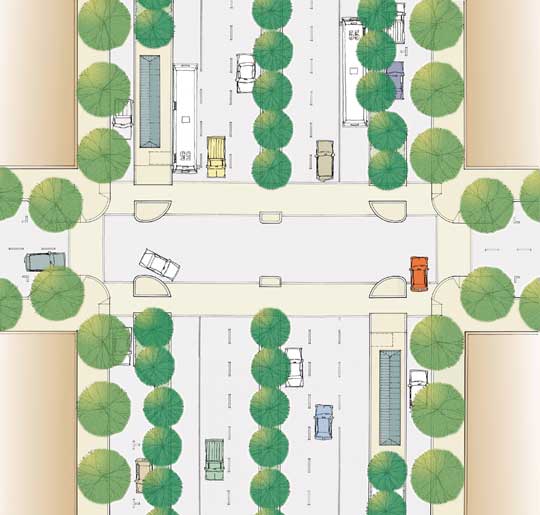
Multiway boulevard. Image credit: NY5 Central Avenue and State Street Land Use & Transportation Study
Multiway boulevards have central lanes that handle large amounts of relatively fast through traffic, plus access lanes on the sides that serve slower local traffic. Generous medians provide landscaping and pedestrian facilities such as promenades, benches, transit stops, etc. Unlike conventional arterials, the sidewalks of boulevards can be pleasant enough for cafes, flea markets, street vendors and public gatherings. Well-designed boulevards knit communities together rather than dividing them.
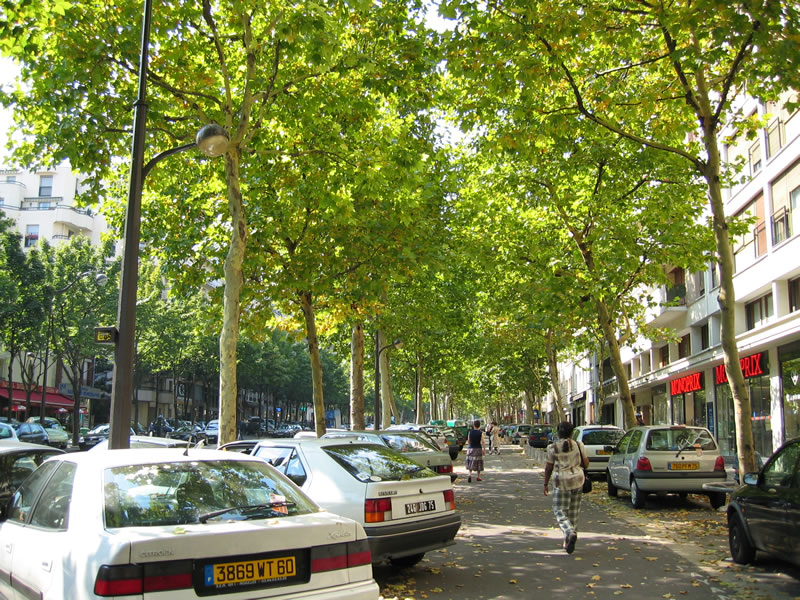
Avenue Daumesnil in Paris. Photo by Payton Chung
In The Boulevard Book (2002), crash records from 19 multiway boulevards in the U.S and Europe were compared with data from matching non-boulevard nearby streets. The authors found that boulevards were comparable to standard urban arterials in terms of safety; in some cases the boulevards were more safe. The conclusion of the study is the clearest statement of pedestrian oriented design, passive safety, and traffic engineering assumptions:
… boulevards are not inherently more dangerous than ordinarily configured arterial streets. The data gathered across the United States and in Europe do not support the prevailing professional view that they are.
The data we were able to obtain are not detailed enough with respect to the exact location of accidents or their physical circumstances to let us say positively that boulevards function more safely than other types as major city streets. Indeed, the paucity of data — and the general lack of precision about these matters — is surprising; it also reinforces our belief that the original indictment of boulevards was not the result of careful studies of accidents and their causes but of reasoning from the statistical probability of conflicts at intersections.
Such reasoning, which equates the statistical probability of conflict between movements with the physical possibility of accidents, does not take into account people’s ability to adapt their behavior in ways that ensure their personal safety. When a situation is complex, drivers and pedestrians use greater caution. Thus, eliminating conflicting movements and simplifying movement channels can have the paradoxical effect of creating more danger; drivers and pedestrians alike may believe the situation to be free from conflict when it is not. Adaptive behavior, however, requires an environment that provides clear information to drivers and pedestrians. A well-designed boulevard … provides that information.
— The Boulevard Book, p. 110
Connectivity in the United Kingdom
In March 2007, the UK government released its Manual for Streets, a technical guidance document for the design of thoroughfares. While it focused on lightly-trafficked residential streets, many of its key principles may be applicable to busy multi-functional streets. The Manual replaced the previous guidance document that was originally written in 1977. It put a new focus on the role of streets as community places, on pedestrian- and bicycle-oriented design, and on inclusive planning. It highlighted the importance of connectivity:
Street networks should, in general, be connected. Connected, or “permeable,” networks encourage walking and cycling, and make places easier to navigate through. They also lead to a more even spread of motor traffic throughout the area and so avoid the need for distributor roads with no frontage development. …
Internal permeability is important but the area also needs to be properly connected with adjacent street networks. A development with poor links to the surrounding area creates an enclave which encourages movement to and from it by car rather than by other modes.
— Manual for Streets
, pp. 41-42
Because there was little robust research that supported the previous standards, the UK government commissioned a study of the safety impacts of street design. This was published as The Manual for Streets: evidence and research. One topic of investigation was crash safety at intersections.
Twenty survey sites throughout the UK were selected, a mix of new and historic neighborhoods. The researchers recorded intersection geometries and vehicle speeds. Crash data for the period 1995-2005 were collected for 187 intersections and 74 linking street segments. The intersections had a higher crash rate than the links, but the collisions were much less severe. Because of reduced sight lines, drivers were more cautious at intersections and reduced their speed accordingly. Overall there were far fewer severe and fatal collisions at the intersections than the links.
Another question researchers sought to answer was whether highly-connected (“more permeable”) layouts were associated with more crashes than low-connectivity cul-de-sac layouts. The researchers applied crash forecasting software to a low-connectivity cul-de-sac neighborhood in Leicester. The modeled crash rate was compared to the actual crash rate reported, and the two figures were in “good agreement.” (Note however that the neighborhood was still under construction.)
Next, the model layout was altered to eliminate cul-de-sacs, increase permeability and make the layout “more organic.” The predicted crash rate of this new layout was very close to the low-connectivity model — an overall increase of 0.07 crashes per year. Then, two major intersections were replaced by roundabouts. The predicted crash rate dropped to a level slightly below that of the low-connectivity model — an overall decrease of 0.09 crashes per year.
In summary, the Manual for Streets stated, “Research shows that there is no significant difference in collision risk attributable to more permeable street layouts.”
The big picture
The final, and in all likelihood, terminal flaw in the conventional traffic safety paradigm is its inability to perceive the big picture. The standards and recommendations of conventional traffic engineering focus on individual roadway segments, and remain blind to system-wide impacts. Cumulatively they add up to auto-dependent sprawl: living environments where walking is unsafe and unpleasant, where carrying out each and every daily task requires climbing into a car. This leads directly to a unintended result. Because the residents of suburbia drive so much, they are more likely to die in traffic crashes.
For a study published in the September 2003 American Journal of Public Health, Ewing et al. developed a “sprawl index” based on population density and connectivity as measured by block size. The sprawl indexes of 448 counties were compared with traffic fatality rates. Ewing found that a high sprawl index was strongly associated with a high traffic fatality rate. The most sprawling counties had fatality rates more than eight times (800%) higher than the least sprawling counties.
In Mortality Risk Associated With Leaving Home (2003), William Lucy studied 15 metropolitan areas comprising 118 cities and counties, over various time periods from the late 1970s to the late 1990s. The results were strikingly consistent: Low density counties always had the highest traffic fatality rates. The most dangerous counties were exurban, while central cities and inner suburbs were the safest. Additional research reported by Lucy and Phillips in their book Tomorrow’s Cities, Tomorrow’s Suburbs supported these findings.
The National Highway Traffic Safety Administration publication Traffic Safety Facts 2005 reported some interesting statistics. They indicate that low-speed urban intersections are not the predominant location for fatal crashes.
- Only 7% of fatal crashes were in urban speed zones of 30 mph or less.
- 51% of fatal crashes occurred in speed zones of 55 mph or more.
- 54% of fatal crashes occurred in rural areas, but less than 21% of U.S. population lives in rural areas.
- 72% of fatal crashes were not related to intersections.
Proponents of access management like to argue that low-connectivity arterials reduce traffic delay and the resulting pollution, and thus increase fuel efficiency. Again, this micro-focus on roadway segments misses the system-wide view. Numerous studies from around the world have found that high-connectivity, pedestrian-oriented neighborhoods and cities enjoy fewer vehicle miles driven and less pollution generated per capita.
Claims to authority
Given its claims to indisputable authority, one might wonder how the traffic engineering profession can discount or reject empirical evidence and adhere to counterproductive recommendations. Other commentators have noted the profession seems unusually susceptible to blinkered, dogmatic thinking. In her books, Jane Jacobs described citizen campaigns against roadway expansions that were deemed absolutely necessary by engineering models. Where the opposition was successful, Jacobs observed that the predictions of gridlocked traffic failed to materialize. Formal studies have confirmed this effect in dozens of cases around the world.
In what traffic engineers have chosen to do and have recommended, they have abandoned and betrayed science as it is understood. …
I thought sadly, “Here they are, another generation of nice, miseducated young men, about to waste their careers in a fake science that cares nothing about evidence; that doesn’t ask a fruitful question in the first place and that, when unexpected evidence turns up anyhow, doesn’t pursue it; a science that hasn’t been building up a coherent body of knowledge that organizes its own direction by grace of the succession of questions it opens.”
— Dark Age Ahead, pp. 72, 74
The authors of The Boulevard Book make similar observations about authoritativeness in traffic engineering:
Yet overwhelmingly the voices of separateness continue to rule in regard to roadway location, size and design in favor of separate uses, separate lanes, separate functions, separateness. Professionals raised and nurtured under such a philosophy are accustomed to being listened to and followed. Certainly they are not challenged when they invoke the magic word, safety, and they are themselves perhaps unaware that their own standards and norms may not be based on real data and actual experience but on professional dogma.
— The Boulevard Book, pp. 92-93
In Roughly Right vs. Precisely Wrong, Donald Shoup revealed how the ITE’s Trip Generation manuals present figures with high precision — down to two decimal places. Yet the ITE numbers are derived from insufficient evidence that lacks adequate statistical support. The numbers have a faulty theoretical basis as well. Much of the nation’s roadway sizing guidelines and parking requirements are based on these manuals.
The eminent transportation professor Ezra Hauer commented about the quality and rigor of traffic safety research:
And yet, there is a certain lightness with which research results are published, a lightness that has no counterpart in other disciplines that also affect life and limb (e.g., medicine). As before, the issue is research quality control. The issue is not merely how to secure the competence of peer reviewers and their independence. A great deal of money has been invested in road safety research and there is too little of good quality product to show for it. Therefore the broader issue is how to improve the quality of road safety research.
— Fishing for Safety Information in the Murky Waters of Research Reports
Steps toward reform
In the realm of engineering streets for safety and pedestrian and cyclist usage, Western Europe leads the world. The UK Manual for Streets is close to ideal in the principles it advocates, including connectivity. Mainstream practice in the U.S. has responded to these issues in a limited and compromised way. But there is cause for hope.
As is observed in The Boulevard Book, relatively few roadway design standards are stated as requirements. Rather, they are recommended standards, and a great deal of discretion is left in the hands of engineers. And while fear of lawsuits and liability may be the single biggest obstacle to innovation, some legal experts argue that reform has a sound legal basis.
A few advanced state guidelines are beginning to recognize that short blocks are an essential feature of walkable built environments. One example is the State of Minnesota’s Access Category System and Spacing Guidelines. The guidelines recommend intersection spacing of 300-660 feet in urban core areas — even on arterials. But this is mostly for existing urban areas; new construction is generally forced into the standard suburban format. Once the low-connectivity template gets locked in place with cul-de-sacs and access-managed arterials, it is very resistant to change.
The ideal (and traditional) solution is for connectivity and development to increase concurrently and in harmony. As properties are subdivided and developed, the neighborhood character becomes more urban; more streets and intersections are established, and blocks become more mixed use and walkable. This form of incremental urbanization was common throughout history. For today’s technocratic zoning departments, the SmartCode codifies the process of urban succession in an open source zoning code.
A movement called Context Sensitive Solutions has gained some measure of success over the past decade. It advocates a more inclusive planning process, responsiveness to local context, and flexibility in design. An allied movement, called Complete Streets, focuses on street designs that serve multiple users — pedestrians, cyclists, transit riders, the disabled, etc. These movements are all to the good, but they do not address connectivity very effectively. They tend to retain the functional classification hierarchy with its primary priority of high vehicle speed, and they offer little opposition to the passive safety paradigm.
Professional organizations are issuing guidebooks that recommend connectivity. Years of advocacy by engineer Walter Kulash culminated in Residential Streets (2001) published by the Urban Land Institute. In 2006, the Institute of Transportation Engineers released its manual for major thoroughfares in walkable communities, developed in partnership with the Congress for the New Urbanism. The ITE-CNU manual is one of the best U.S. guidebooks, with strong advocacy for high connectivity. The manual has its shortcomings, however. It continues the functional classification hierarchy which is inherently opposed to highly connected arterials — and leaves that conflict unresolved. Also, the manual’s connectivity discussion fails to grapple with safety issues.
In May 2007, the CNU released its 5-year strategic plan with a set of actions to correct the deficiencies of the ITE manual. The plan has these objectives:
- Incorporate New Urbanism comments in the completion of the Context Sensitive Solutions for Urban Thoroughfares manual by the end of 2007.
- Develop a CNU companion document to the ITE manual to clarify thoroughfare design practices that meet new urbanist standards by 2009.
- Begin the development of a second design manual for small streets and the network, starting with the 2008 Transportation Summit.
- Develop relationship with Federal Highway Administration by 2008, so its contributions to future manuals are compatible with neighborhood form and function.
These initiatives deserve all the help and support that can be mustered.
As built projects and best practices collect operating experience in Europe, in other parts of the world, and in a handful of U.S. cities, there are more examples to visit in person and study. A handful of successful reform practices can have a powerful influence, even in a land that is overwhelmingly dominated by conventional, suburban-template roadway design practices.
Seeing is believing, and experience counts! When reviewers, professional or otherwise, can relate a proposal to a successful design they have actually experienced, they tend to be more accepting of it, even if it runs counter to existing norms. The wholeness of one’s experience, recalled or of the moment, takes ascendancy over piecemeal analysis.
—The Boulevard Book, p. 238
Hope for better-quality built environments can be found in the sizable contingent of planners, designers, engineers and public officials who have learned about these issues, taken the time to study best examples, and advocate and work for reform. What’s true in most aspects of urban design is also true of thoroughfares: The best teacher is direct personal experience. On foot, if possible.
Resources
UPDATE 18 Nov 2008: Two Connectivity Studies for 2008 linking increased street connectivity with improved safety outcomes.
CNU/ITE Street Design Manual — Resources about ITE’s Context Sensitive Solutions manual that was developed in partnership with the Congress for the New Urbanism.
Complete the Streets — Advocates street designs that integrate the needs of bicyclists, pedestrians, transit users and disabled people.
Context Sensitive Solutions.org — An online resource center for Context Sensitive Solutions.
FHWA and Context Sensitive Solutions — FHWA’s involvement with CSS and related activities being sponsored or championed by the FHWA.
FHWA Safety: Intersections — The FHWA Office of Safety provides intersection safety engineering and outreach tools.
Octavia Boulevard Project website — Provides information on the design of Octavia Boulevard and related ancillary projects in San Francisco.
Pedestrian and Bicycle Information Center — Promotes safe walking and bicycling through information and research, technical assistance and networking.
TRB Access Management Committee — Shares knowledge, expertise and experience to advance access management and its integration into planning.
Vehicle speed and pedestrians:
- Slowing Down Traffic — Safe Routes to School pamphlet
- Improving Traffic Safety: Reducing Deaths and Injuries through Safer Streets — STTP Pamphlet
- Effects of Vehicle Speed on Pedestrian Fatalities — A short article with citations
- Literature Review on Vehicle Travel: Speeds and Pedestrian Injuries (1999) — The most complete literature review, from the U.S. DOT
- Pedestrian Safety Benefits of Speed Reduction (2006) — U.S. DOT study with updated literature review
Bibliography
Community Design + Architecture et al., NY5 Central Avenue and State Street Land Use & Transportation Study. Prepared for Capital District Transportation Committee, September 2001. See ny5.org for additional materials.
Demosthenes, Philip, Access Management Policies: An Historical Perspective. Prepared for the International Right-of Way Association Conference, Albuquerque, NM, June 1999.
Dumbaugh, Eric, Safe Streets, Livable Streets: A Positive Approach to Urban Roadside Design. Dissertation Presented to Georgia Institute of Technology, August 2005.
Dumbaugh, Eric, The Design of Safe Urban Roadsides: An Empirical Analysis. TRB 2006 Annual Meeting CD-ROM.
Dumbaugh, Eric, Safe Streets, Livable Streets. Journal of the American Planning Association, Vol. 71, No. 3, Summer 2005.
Ewing, Reid, Richard A. Schieber and Charles V. Zegeer, Urban Sprawl as a Risk Factor in Motor Vehicle Occupant and Pedestrian Fatalities. American Journal of Public Health, Vol 93, No. 9, September 2003.
Federal Highway Administration, FHWA Functional Classification Guidelines. U.S. Department of Transportation, 1989.
Gladwell, Malcolm, Wrong Turn: How the fight to make America’s highways safer went off course, The New Yorker, June 11, 2001.
Gluck, Jerome, Herbert S. Levinson and Vergil Stover, Impacts of Access Management Techniques. NCHRP Report 420, Transportation Research Board, Washington, D.C., 1999.
Handy, Susan, Robert G. Paterson and Kent Butler, Planning for Street Connectivity: Getting From Here to There. Planning Advisory Service Report 515, American Planning Association, 2003.
Hauer, Ezra, Fishing for Safety Information in the Murky Waters of Research Reports. Paper prepared for Annual Meeting of the Transportation Research Board, January 2002.
Institute of Transportation Engineers, Context Sensitive Solutions in Designing Major Urban Thoroughfares for Walkable Communities. Washington D.C., 2006.
Jacobs, Allan B., Elizabeth Macdonald and Yodan Rofé, The Boulevard Book: History, Evolution, Design of Multiway Boulevards. MIT Press, 2002.
Jacobs, Jane, Dark Age Ahead. Random House, 2004.
Jacobs, Jane, The Death and Life of Great American Cities. New York: Random House, 1961.
Jacobsen, Peter L., Safety in numbers: more walkers and bicyclists, safer walking and bicycling. Injury Prevention, Vol. 9, No. 3, 2003, pp. 205-209.
Jones, Richard O., Context-Sensitive Design: Will the Vision Overcome Liability Concerns? TRB 2004 Annual Meeting CD-ROM, Transportation Research Board, 2004.
Kulash, Walter, Joe Anglin and David Marks, “Traditional Neighborhood Development: Will the Traffic Work?” Development 21, July/August 1990, pp. 21-24. See also a related presentation made at the 11th Annual Pedestrian Conference in Bellevue WA, October 1990.
Kulash, Walter, Residential Streets, Third Edition. Urban Land Institute, 2001.
Leden, Lars, Pedestrian risk decrease with pedestrian flow. A case study based on data from signalized intersections in Hamilton, Ontario. Accident Analysis & Prevention, Vol. 34, No. 4, July 2002, pp. 457-464.
Lucy, William H., Mortality Risk Associated With Leaving Home: Recognizing the Relevance of the Built Environment. American Journal of Public Health, Vol. 93, No. 9, September 2003, pp. 1564-1569.
Lucy, William and David Phillips, Tomorrow’s Cities, Tomorrow’s Suburbs. APA Planners Press, 2006.
Macdonald, Elizabeth, Building a Boulevard. Access, No. 28, Spring 2006, pp. 2-9.
National Center for Statistics and Analysis, Traffic Safety Facts 2005. National Highway Traffic Safety Administration, U.S. Department of Transportation, 2006.
Raford, Noah and David R. Ragland, Space Syntax: An Innovative Pedestrian Volume Modeling Tool for Pedestrian Safety. Paper UCB-TSC-RR-2003-11. UC Berkeley Traffic Safety Center, December 2003.
Shoup, Donald, Roughly Right vs. Precisely Wrong, Access, No. 20, Spring 2002, pp. 20-25.
Transportation Research Board, Access Management Manual, 2003.
Transportation Research Board, Driveway and Street Intersection Spacing. Transportation Research Circular Number 456, March 1996.
U.K. Department for Transport and Communities and Local Government, Manual for Streets, 2007.
Williams, Kristine M., “External Connectivity and Sprawl.” Letters to the Editor, Journal of the American Planning Association, Vol. 70, No. 4, Autumn 2004, p. 481.
York, I., A. Bradbury, S Reid, R Paradise, The Manual for Streets: evidence and research. TRL Report TRL661. Prepared for UK Department for Transport by TRL Limited, 2007.
I was disappointed by the article “Connectivity Part 7: Crash Safety Posted by Laurence Aurbach under Thoroughfares. Rather than looking at the larger urban and suburban fabric, the article is a myopic view of the value of well designed neighborhoods while negating the benefits of access management.
The article ignores the community’s needs and demands for mobility. It never mentions the level of carnage on public roads. Over 830 fatalities weekly including 45 children, and 7,400 injuries daily. Access management achieves crash reductions of 30 to 60%. Access related crashes are over 65% of the total in urban areas. Every day, members, friends and relatives in our communities are lost forever, or are hospitalized. The most likely cause of accidental death in the USA is a traffic ‘accident’.
I am a supporter of good neighborhood design and livable streets. But the transportation system is much larger than that and a vital part of American prosperity. Finding the balance between the needs of neighborhood public ways and the collector and arterial regional distributors is a challenge to land use development, urban design and agency institutional policies and procedures.
Access management is not wrong as Aurbach seems to suggest. Access management is set of strategies, technical tools, that if used wisely and in context with the community, improves the quality of life by improving the quality of travel and the safety of all users of public ways.
Thank you, Mr. Demosthenes, for your comment. Let me also say that I appreciated your paper about the history of access management; it provided useful background information.
I fully agree that the level of carnage from traffic crashes in the U.S. is horrific. That was in large part the motivation for writing this essay. As I pointed out, over the past 40 years the U.S. per-capita traffic fatality rate went from one of the best in the developed world to one of the worst in the developed world. The U.S. improved over that time period, but the European nations improved much more. The U.S. traffic engineering profession should learn from the principles underlying Europe’s superior performance, including livable streets and walkable, highly connected neighborhoods.
There is no doubt that the statistics Demosthenes cites are accurate. However, as I argue in the essay, the devil is in the details. Access related crashes are 65% of the total in urban areas, but are we talking about exurban, suburban or livable contexts? Demosthenes cannot answer that question, because the traffic engineering field as a whole cannot answer that question. Context is simply not on their safety research agenda, in spite of the fact that it plays a major role in traffic crashes.
Demosthenes wrote:
This pair of sentences crystallizes the cognitive dissonance inherent in much of traffic engineering thinking. The community’s needs and demands for mobility — realized in the form of high speed, passive-safety thoroughfares — are directly responsible for the level of carnage on public roads.
One solution — the conventional solution — is to build ever larger, ever faster arterials carrying traffic ever longer distances, and then to restrict connectivity in an effort to compensate for the dangerous conditions that result. I advocate a more direct and efficient solution: Walkable neighborhoods. Reducing the number of miles people have to drive. Making streets livable, safe and inviting for pedestrians. Providing bike, transit and other travel alternatives.
When Demosthenes mentions prosperity, I assume he is referring to congestion, hours of delay in traffic and the associated costs. As I described in Vehicle Miles and Traffic, greater connectivity can reduce congestion. Walkable neighborhoods with livable streets reduce per capita VMT. Alternative travel modes like biking and transit are much more viable with livable and well-connected street layouts.
Access management does have certain benefits. I hope no one assumes that I am opposed to all aspects of access management. As I mention in the essay, limiting the number of driveways on arterials is beneficial. What I am specifically arguing against are intersection spacing standards that mandate long, unwalkable blocks for livable streets.
Finding balance is indeed a challenge. In my opinion, the balance has been wildly tilted in favor of automobiles for many years. In the spirit of better balance, I hope that Demosthenes and his like-minded colleagues will investigate in more detail the multiple benefits of livable streets, short blocks and highly connected street layouts.
Interesting discussion. As you noted with regard to MnDOT, state access management policies typically offer a range of spacing criteria for various environments. These criteria can accommodate walkable blocks, even on major arterials. Florida DOT, for example, allows spacing of 440 or 660 feet on its strategic arterials as they pass through urban areas. Better yet if these were streets and blocks, rather than the more typical driveways to commercial strip development or single access subdivisions.
The bigger problem with regard to livability and modal options is inadequate local street network development. Master street plans are starting to catch on (again) and local access management policies are helping accomplish a more diverse and connected street network in urban areas. Unfortunately, most corridor development is administered incrementally, rather than in the context of a detailed development/street plan. Corridor access management plans are a great tool in that regard and can form the basis for development of livable, walkable places with highly connected street networks and modal options.
The usual design approach for livable corridor redevelopment is to focus on good, pedestrian oriented frontages. Here is a visualization of such a project and here is another. When parking lots and drive-thru businesses are replaced with pedestrian oriented frontages, the number of curb cuts is automatically reduced. At the same time, the number of street connections is maintained or increased. Access management in that case is a byproduct rather than a starting point.
I am not aware of any corridor access management plans that have formed the basis for livable streets, but would be interested to learn about any existing examples.
Master street plans can be a great tool, and of course many popular and successful American neighborhoods are based on master street plans. On the other hand, in the documentary Contested Streets, planners in Copenhagen make an intriguing point. They say Copenhagen’s 40-year redevelopment as a pedestrian and bicycle oriented city could never have proceeded under a master plan. There would have been too much opposition, too much resistance. In Copenhagen, the incremental strategy has been much more viable and has produced excellent results.
Interesting discussion. I’m familiar with Phil, more on the topic of roundabouts than access management, but I agree with his position and beliefs in the benefits of access management.
Being a traffic engineer, I feel I’m being placed in a generalized category of nerds who just follow standards set before them with no understanding of context and no real ability to think for myself. That’s insulting. I got the same feeling as I read through The Boulevard Book. There may be some out there that fit that mold, but let’s be clear that the reference to “traffic engineers” is certainly not all-inclusive.
I work in Chicago and deal with many projects in vibrant, urban, and downtown neighborhoods. I take the L to work everyday. My family has just one car… we walk a lot. I’m all for livable streets that are walkable and accommodate multiple users from autos to bicycles to pedestrians to transit. I don’t go to work trying to reduce access, widen roads, and limit connectivity.
I’ve worked on many studies in Chicago in neighborhoods with a lot of pedestrian activity, transit use, and a traditional street grid (some with 300-foot blocks), but most of those cases, traffic sucks. That’s just reality… many people will continue to insist on driving. We just need to manage it the best we can and incorporate design aspects that make it easy to walk, accommodate transit, and improve the overall character of the area.
I’m all for reducing our dependence on private auto and using other modes to get around. But in most suburban and rural areas, walking is typically not a viable option for most people. Whether that is a function of roadway design or land planning may be debatable. Is it the classic chicken-and-egg situation.
I think providing livable streets that are walkable, safe, and inviting for all users has as much to do with land use planning, if not more, than traffic engineering. If people have nothing to walk to, I don’t care how short your blocks are. Land uses need to be more integrated with each other. I’ve never been asked to design the roadway system for a new development as a starting point. Planners are typically responsible for that. In most cases, it seems driven by getting the right number of units or square footage in the plan, getting the stormwater and utilities to work, and then trying to make the transportation work for that plan.
Unfortunately, I think the way most communities, outside of existing urban areas, are formed these days by the decisions of politicians and commission members who don’t have a clue about good land use and transportation planning. They lack vision and the willingness to try something because it may be unconventional or unpopular among constituents (who more often than not are complaining about traffic).
Sorry for the rant, but I think your blanket take on traffic engineers is a gross mischaracterization.
Peter, based on your description, you and engineers like yourself who work to improve the walkability and livable character of thoroughfares are a precious national resource. You are part of the “sizable contingent” that I describe in the concluding paragraph of this essay — those who are cause for hope that better-quality built environments can become widespread and commonplace in the U.S.
If only you were representative of the mainstream of the traffic engineering profession. Sadly, traffic engineers who are skilled, dedicated and knowledgeable about livable thoroughfares and the making of walkable communities are a tiny minority within the profession as a whole. I am glad to hear you do not “go to work trying to reduce access, widen roads, and limit connectivity,” but that is in fact the standard operating procedure for most new construction in the United States. There are thousands of practitioners who can confirm that unfortunate truth from personal experience. If it was not the case, there would be no need for initiatives like the ITE’s Context Sensitive Solutions for Urban Thoroughfares manual.
Having evaluated over 1,000 plans for new walkable developments, I have a solid basis for observing that the biggest, most common flaw is lack of external connectivity. You say that planners, politicians and commissioners are responsible, but those folks will usually say they are following the directives handed down by traffic engineers. And so the buck is passed along in an endless circle of denied responsibility. At least in the planning realm, the major professional organization (APA) has adopted an official policy that gives high priority to street connections in transportation systems. In the realm of traffic engineering, the leading organizations (AASHTO, ITE, etc.) have adopted no comparable policy position.
I agree with your observations about land uses and connectivity. As I wrote in Part 4: Neighborhood Walking: “A consistent theme running through the studies is that connectivity works synergistically with other urban design elements to support walkability. When tested by itself, connectivity may show little relationship with walking. When tested in concert with other design elements like proximity to mixed use, connectivity has a significant impact on walking.” See the rest of Part 4 for more detail on this topic.
You ask whether unwalkable suburbs are a function of roadway design or land planning. However, roadway design and land use planning need not be in conflict nor mutually exclusive. That dichotomy may be common in conventional planning, coding and regulatory regimes, but is unnecessary and unneeded. Roadways and land uses can be coordinated through comprehensive urban design. For instance, the rural-to-urban transect, a concept that dates back to Patrick Geddes, can be adapted as a zoning code that address a full spectrum of walkable environments. Such codes can harmonize thoroughfare configuration, land uses, building form, setbacks, frontages, and other elements of urban design. A number of communities nationwide are adopting transect-based codes; the largest is Miami.
Finally, a word about insults. I have endeavored in this essay to place responsibility on the standards and practices of the traffic engineering profession, not on individuals. I suppose the degree to which one feels insulted depends on the degree to which one identifies with those standards and practices. But they have delivered inferior safety performance, as well as inhospitable thoroughfares that function poorly for pedestrians, cyclists and transit. They contribute to a low degree of livability in built environments. Based on the record and the evidence, those standards and practices deserve all the criticism put forth in this essay.
Very stimulating conversation on the safety of public ways. Can’t say I agree with many points, but it is one of the few, if any, web pages that approaches the issues from very different goals and objectives, thereby finding new perspectives on the basis of safety problems and their causes.
I think modern roundabouts replacing traffic signals holds great promise on calming urban traffic and helping achieve a better balance between the vehicle dominated roadway and the rest of the environment. I do support a system hierarchy with high speed arterials, but once below 45, when all the multi use interaction begins, both negatively and postively, I think roundabouts will significantly improve the quality of life on and near these roadways.