
This is part 6 of a series. See also Introduction • Historical Background • Latter Half of the 20th Century • Neighborhood Walking • Neighborhood Crime • Crash Safety
Automobiles have brought many benefits to society, and at the same time there are many good reasons to reduce the number of vehicle miles traveled (VMT) each year. Thoroughfare connectivity is part of the strategy that reduces VMT; it is a necessary, but by itself insufficient, component of walkable environments. Also, well-connected thoroughfares can reduce traffic congestion by providing alternate travel routes, and can speed emergency services by providing more direct routes and better accessibility.
There’s a nascent movement to advance better-connected thoroughfares, but meanwhile the inertia of preexisting standards and regulations discourages or prohibits high connectivity for most new construction. In addition, NIMBY residents are frequently opposed to new street connections. Future trends in energy, environmental and cultural conditions, however, could lead to walkable, well-connected thoroughfare layouts becoming more customary.
Connectivity and VMT
Following the rise of the environmental movement in the 1960s and the oil supply shocks of the 1970s, research began into the harmful impacts of mass car use. An editorial titled The Road Less Driven by Susan Handy (2006) summarizes the burdens of explosive growth in automobile travel and the justifications for reducing VMT. Handy identifies impacts ranging from air pollution, cost and energy insecurity to congestion, crashes and climate change.
The literature on the built environment and travel is voluminous, having begun in the 1950s and expanded greatly over the past twenty years. Some extensive summaries of the more recent work include:
- How Land Use and Transportation Systems Impact Public Health, by Lawrence Frank (2000) is an annotated bibliography that describes 28 studies related to VMT.
- Our Built and Natural Environments, by U.S. EPA (2001) has a section on VMT that cites a dozen sources, including simulation models and empirical studies.
- “Travel and the Built Environment: A Synthesis,” by Ewing and Cervero (2001) is a meta-analysis that incorporates more than 50 empirical studies.
- Influence of Built Form and Land Use on Mode Choice, by Reilly and Landis (2003), reviews two dozen studies in its preface.
- Smart Growth and the Transportation-Land Use Connection, by Susan Handy (2005) is an overview that discusses several dozen of the most notable studies. Handy notes that more than seventy studies published during the 1990s explored and quantified the relationships between built environment and travel behavior.
Early investigations (1970s to 1990s) found that that as urban density increases, VMT per person decreases. Each doubling of density results in a VMT reduction ranging from 20 to 30 percent, leading to major improvements in per-capita efficiency and environmental measures. However, many commentators have observed that density is largely a proxy for other important aspects of the built environment. In response, research has become more specific, fine-grained, and methodologically complex. Some researchers have focused on quantifying the influence of urban design factors including connectivity.
Ewing and Cervero (2001) combined the results of more than 50 studies to estimate the separate impacts of local and regional mixed use, density, and urban design including connectivity. They found that, by itself, each doubling of the urban design score reduced VMT by 3 percent.
Reilly and Landis (2003) analyzed a 1996 travel survey of 14,400 Bay Area residents. They found that a 25% increase in intersection density, representing the difference between suburban Concord, CA and central Palo Alto, CA, increased the probability of walking by 45% and the probability of using transit by 62%.
The SMARTRAQ study (2004) used travel surveys from 8,000 households in Atlanta. The study defined walkability as a combination of residential density, land use mix, and street connectivity.
SMARTRAQ found that people who live in neighborhoods with the lowest walkability drive an average of 39 miles per person each weekday, 30 percent more than those who live in areas with the highest walkability. The difference for weekend travel was even greater. On average, residents in the most walkable neighborhoods drive about 40 percent less on the weekend than their counterparts in low-walkability neighborhoods.
— SMARTRAQ Summary Report p. 9
The 5-year LUTAQH study (2005) analyzed VMT in the Puget Sound area. The analysis controlled for the influences of demographics, vehicle ownership and transit availability.
The greatest differences in VMT were observed across levels of intersection density (street connectivity), where mean VMT was 34 miles per person in the least and 25 miles in the most connected environments of King County. This represents 26% fewer vehicle miles of travel for residents who live in communities that have the most interconnected street networks in the county.
— LUTAQH p. 129
These studies and others give results similar to research on connectivity and walking. By itself, the influence of connectivity is indeterminate or small. When connectivity is applied in concert with local and regional proximity to mixed use, high quality transit service, moderate-to-high residential density, and other urban design factors, the VMT reduction effect is substantial. It is a synergistic effect.
Mixed Use, Density, and Connectivity are Synergistic — Land use policies required to reduce auto dependence need to encourage both proximity (density and mixed use) and connectivity. The consolidation and intermixing of land use combined with increased street connectivity offers an important part of the solution to improve air quality. However, increasing the levels of density and land use mix alone will not yield effective changes in travel patterns without increased connectivity for local access on foot and by bike, and without a regional transit system that is competitive, in terms of time and/or out of pocket cost, with the private vehicle.
— SMARTRAQ Final Technical Report, p. 290
Self-Selection
Connectivity Part 4 discussed how self-selection operates with respect to neighborhoods and walking; the same self-selection issues are in play for driving. In other words, there’s a certain amount of sorting going on. People who prefer walking, biking and transit often choose to live in walkable, transit oriented neighborhoods where driving isn’t an absolute requirement. When self-selection happens, urban design enables a change in travel behavior but might not cause it.
On the other hand, recent research is showing that urban design can indeed have causal impacts — it can change travel behavior.
Handy et al (2004) studied the attitudes and travel behaviors of over 1600 Northern California residents. They found that “a change in accessibility (e.g., easy access to shopping malls and downtown, stores within easy walking distance) is the most important variable in predicting changes in driving” — more so than preexisting preferences. The authors recommend policies to increase accessibility, especially mixed-use zoning and “street connectivity ordinances that ensure more direct walking routes between residential and commercial areas.”
Krizek (2003) studied the travel diaries of 430 Seattle-area households that moved from one neighborhood to another. The study found that VMT was significantly affected by “neighborhood accessibility” (a combination of density, mix of uses, and street pattern).
I model a typical relocation of a household from a traditional single-family home in Seattle to a suburban development in Bellevue. Assuming median values for all other variables, the model predicts that this relocation would result in an increase of over 5 VMT per day per household. Thus, not only does the land use/transportation relationship appear to make a difference at both the regional and local levels, but by most standards the magnitude of the increase — 5 miles per day per household — deserves attention from the planning community.
— Residential Relocation and Changes in Urban Travel
Connectivity, Congestion and Access
Dendritic thoroughfare networks — those that branch like a tree and end in cul-de-sacs — are inherently worse for traffic congestion. All of the through traffic is channeled into a few arterials, creating major bottlenecks and tie-ups when traffic volume gets heavy. Conversely, well-connected thoroughfare layouts such as grids are able to distribute traffic among many alternate routes. Well-connected layouts handle the same volume of traffic with less congestion.
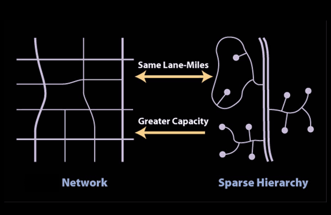
Thoroughfare connectivity comparison. Image from presentation titled “Narrow Streets, Timely Response” by Dan Burden
Portland Metro (2004) reported the results of five case studies in the Portland, OR area. It found that moderate to high local street connectivity reduced traffic demand on major streets, delay at major intersections, and overall vehicle traffic demand. The report recommended intersection spacing between 330 and 530 feet as the most cost-effective method of improving regional street flow.
The report also recommended that potential cut-through impacts be addressed:
Providing an interconnected street system can lead to some environmental and capacity impacts. The primary impacts are diversion of local and regional traffic into residential neighborhoods, and additional connecting intersections reducing the overall capacity of regional streets. However, with proper planning, these impacts can be mitigated or avoided altogether.
The recommended measures include traffic calming, signage, intersection design, driveway consolidation, and signal light timing.
The comprehensive reference report, Traffic Calming: State of the Practice (1999) covers many techniques for calming cut-through traffic without reducing connectivity. These include T-intersections, narrow streets and lanes, curb extensions (bulb-outs), roundabouts, raised medians, chicanes (deflections), parking bays, and pavement surface modifications.
Alba and Beimborn (2005) developed a detailed traffic demand analysis as part of a regional traffic demand model. The analysis found that improvements in connectivity of the local streets reduced traffic volumes along the principal arterials. Furthermore, the model showed that the relative speed differential was determinative. In other words, the greater the speed difference between arterials and local streets, the less cut-through traffic. This implies that highly-connected thoroughfare layouts can be designed to achieve a desired balance between local speed and cut-through traffic volumes.
Planning for Street Connectivity (2003) by Handy, Paterson and Butler reviews 14 street connectivity ordinances in the U.S. The local ordinances mandate certain levels of connectivity to ensure fast fire, ambulance and police response times. Also, the ordinances seek to increase the efficiency and reduce the costs of municipal services, such as school bus routes, routine police patrols, garbage truck routes, snow removal, and water line maintenance.
The benefits of high street connectivity are readily apparent to emergency responders, and they are often strong supporters of connectivity ordinances (Planning for Street Connectivity, p. 17). Swift (2003) writes:
Fire fighters balk at [narrow streets]. They have legitimate concerns about accessing structure fires in confined areas. The solution to this is to provide a connected network of streets and alleys, specific areas for the fire apparatus to operate and well-positioned fire hydrants. A connected network allows for a multi-directional attack strategy. There will be a number of ways to approach the fire.
… A way to reduce the width of a street is to understand that a pumper truck will have at least 150 feet (46 meters) of hose that can be extended to the fire. This means that fire trucks can operate about 260 feet (79 meters) apart as demonstrated in [the figure below]. So-called “red zones” that prohibit parking are established in areas that will experience high parking densities. Alleys are also a very efficient way of attacking a fire because they allow two other means of approaching the incident.
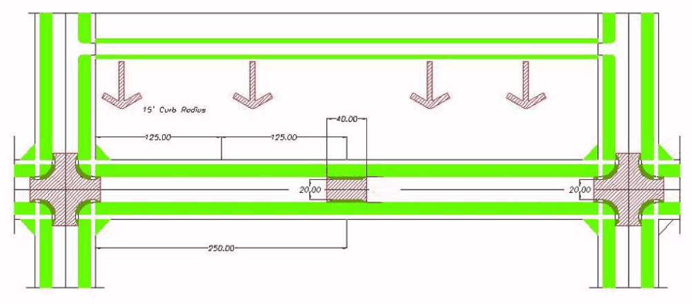
Diagram of fire truck access on connected street network
Policy Positions
Reducing VMT is an official goal of U.S. government policy that has been directed by a variety of federal laws: the Clean Air Act, the Intermodal Surface Transportation Efficiency Act (ISTEA) and the Transportation Equity Act for the 21st Century (TEA-21).
Well-connected street plans are an official policy position of the American Planning Association. The policy guide states, “The American Planning Association and its Chapters support policies and plans that place street connection as a high priority in the development of transportation systems.” The policy was adopted to help achieve the goals of smart growth.
Well-connected street layouts are an essential principle of new urbanism. The Charter of the New Urbanism is clear about this, stating: “Interconnected networks of streets should be designed to encourage walking, reduce the number and length of automobile trips, and conserve energy.” Walter Kulash’s essay in the book Charter of the New Urbanism (p. 83) is a succinct explanation of those reasons.
The Institute of Transportation Engineers publication, Context Sensitive Solutions in Designing Major Urban Thoroughfares for Walkable Communities (2006) is an “ITE proposed recommended practice” that specifies high-connectivity street patterns for improved walkability.
Despite these and other similar policy documents, low-connectivity suburban thoroughfares remain the default for new construction in the U.S. Low-connectivity suburbs became prevalent in the 1930s and 40s (see Part 2 and Part 3 of this series). The institutional habits developed over six decades are powerful drivers of mainstream practice in the engineering, planning and development fields. In government and administration, in academic research, and within the professions, conventional low-connectivity planning contends with advocacy for reform.
Many suburban residents have come to expect the exclusivity and isolation from public civic life that is built into the suburban template. New street connections to adjacent developments are often opposed because of concerns about cut-through traffic. Public education, and addressing residents’ specific concerns, can ameliorate this kind of opposition. The experience in Eugene, OR is illustrative:
While Eugene’s Planning Council was satisfied with the connectivity standards from the onset, staff perceived much opposition from local residents (Jacobson 2002). In many instances they found that the public’s resistance to the standards stemmed from not knowing enough about connectivity and its ramifications. To educate residents, staff went to public forums across the city where they presented their plans. Local residents also attended the public hearings at which the city staff presented their plans to the planning council. The public education process lasted nearly two years, but Jacobson says it was well worth the time and effort.
With time, both developers and residents in Eugene have shown a growing acceptance of the connectivity standards. The developers are now accustomed to applying the standards; local residents also see the dispersal of formerly congested traffic, and “hence there is far less resistance to the connectivity standards in recent times” (Jacobson 2002). Jacobson argues that “selling” the concept of connectivity by articulating its benefits to the community is far more effective than “shoving the concepts down people’s throats.”
— Planning for Street Connectivity, p. 32
Future Scenarios and VMT
The consideration of future trends and scenarios is essential. All research on VMT is based on current conditions, behaviors and social mores. VMT models and expectations often assume that the next fifty years will be similar to the last fifty years. Accumulating evidence suggests that might not be the case.
In February, 2007 the U.S. Government Accounting Office issued a report titled Uncertainty about Future Oil Supply Makes It Important to Develop a Strategy for Addressing a Peak and Decline in Oil Production. The majority of research compiled by the GAO found that the peak of world oil production could occur by mid-century.
U.S. Energy Secretary Samuel Bodman made the following statement on Nov. 13, 2006:
If we look two or three or four decades into the future, we know that hydrocarbons alone will not meet the needs of a growing world economy. Even with all the technical expertise the world could offer and all the political will it could muster, eventually, we will run out of oil. And, even before then, the price of a dwindling supply will be prohibitive. At present, our world is overly focused on, and overly dependent upon, one source of energy. And that path is unsustainable. … We cannot meet future demand with hydrocarbons alone. Period.
Apart from energy constraints, demographic changes are already underway in the U.S. that will lead to increased demand for walkable neighborhoods. As Nelson (2006) points out:
Although I expect over half of all development on the ground in 2025 will not have existed in 2000, even more important is that by 2025 much of society will have been spatially rearranged. An increasing number of empty-nesters, young professionals, and others will choose the city and first-tier suburban locations over outer suburban ones. According to Fishman (2005), they will drive up housing prices beyond the reach of many existing residents who may then be pushed to the suburban fringe and exurbs. Rising energy prices and declining demand for suburban homes on large lots may reduce the value of these homes, yielding important implications for the future.
Nelson draws on studies of planned transit lines and residential demand to conclude that nearly half of new growth in metropolitan areas could be transit oriented development, within walking distance of rail stations.
Given the present benefits of well-connected thoroughfare patterns, and future trends that point toward greater demand for walkable neighborhoods and a variety of transportation alternatives, the potential for connectivity is strong. Throughout history until the 1940s, highly-connected thoroughfare layouts were the standard foundation upon which cities were built. It could well be that connected thoroughfares will once again become the customary practice.
Resources
The 2001 National Household Travel Survey gives a basic picture of travel trends in the U.S. Between 1990 and 2001:
- Daily VMT per driver increased 15%, from 28 to 33 miles.
- Daily VMT per household increased 17%, from 50 to 58 miles.
- Amount of time drivers spent driving increased 26%, from 49 to 62 minutes per day.
The increases were due to more driving for non-work purposes, more cars per household, and more households in sprawling auto-oriented locations.
The 1997 Residential Transportation Energy Consumption Survey chapter on Vehicle-Miles Traveled reviews statistical and demographic information.
The Sierra Club’s sprawl and transportation section provides factsheets, reports, links, articles, and research.
TravelMatters.org — how travel habits and transportation choices affect global climate change. Offers a trio of resources: interactive emissions calculators, on-line emissions maps, and educational materials.
Victoria Transport Policy Institute’s Roadway Connectivity page is part of the Online Transportation Demand Management Encyclopedia.
Bibliography
Alba, Carlos A. and Edward Beimborn, Analysis Of The Effects Of Local Street Connectivity On Arterial Traffic. TRB 2005 Annual Meeting CD-ROM.
Bento, Antonio et al, The Effects of Urban Spatial Structure on Travel Demand in the United States, The Review of Economics and Statistics, Volume 87, Number 3, August 2005, pp. 466-478(13)
Burden, Dan, Emergency Response, Traffic Calming and Traditional Neighborhood Streets. Local Government Commission, 2001. See also a related presentation, Narrow Streets, Timely Response, presented at the 6th Annual New Partners for Smart Growth, February 2007.
Cao, Xinyu, Patricia L. Mokhtarian and Susan L. Handy, Cross-sectional and Quasi-panel Explorations of the Connection between the Built Environment and Auto Ownership. Environment and Planning A, Vol. 39, No. 4, pp. 830-847, 2007.
Ewing, Reid and Robert Cervero, Travel and the Build Environment: A Synthesis. Transportation Research Record, No. 1780, pp. 87-114, 2001.
Ewing, Reid, Traffic calming: state of the practice. Prepared by the Institute of Transportation Engineers for the U.S. Department of Transportation, Federal Highway Administration, August, 1999.
Frank, Lawrence D., Peter Engelke and Daniel Hourigan, How Land Use and Transportation Systems Impact Public Health: An Annotated Bibliography. ACES: Active Community Environments Initiative Working Paper #2, Centers for Disease Control and Prevention, December 2001.
Handy, Susan, Robert G. Paterson and Kent Butler, Planning for Street Connectivity: Getting From Here to There. Planning Advisory Service Report 515, American Planning Association, 2003.
Handy, Susan, Patricia Mokhtarian, Theodore J. Buehler, and Xinyu Cao, Residential Location Choice and Travel Behavior: Implications for Air Quality, UC Davis-Caltrans Air Quality Project, Task Order No.27, 43A0067, December 2004.
Handy, Susan, Smart Growth and the Transportation-Land Use Connection: What Does the Research Tell Us? International Regional Science Review Vol. 28, No. 2, pp. 146-167, April 2005.
Handy, Susan The Road Less Driven. Journal of the American Planning Association, Vol. 72, No. 3, Summer 2006.
Holtzclaw, John C., et al, Location Efficiency: Neighborhood and Socio-Economic Characteristics Determine Auto Ownership and Use — Studies in Chicago, Los Angeles and San Francisco. Transportation Planning and Technology, Vol. 25, No. 1, pp. 1-27, 2002. Much of the same material is covered in Smart Growth — As Seen From the Air, presented at the Air & Waste Management Association’s 93rd Annual Meeting & Exhibition, June 2000.
Krizek, Kevin J., “Residential Relocation and Changes in Urban Travel: Does Neighborhood-Scale Urban Form Matter?” Journal of the American Planning Association, Vol. 69, No. 3, Summer 2003.
LUTAQH: A Study of Land Use, Transportation, Air Quality and Health in King County, WA. Prepared by Lawrence Frank & Co., Inc. et al for King County, WA, December 2005.
Nelson, Arthur C., Leadership for a New Era. Journal of the American Planning Association, Vol. 72, No. 4, Autumn 2006.
Newman, Peter and Jeffrey Kenworthy, Urban Design to Reduce Automobile Dependence. Opolis, Vol. 2, No. 1, 2006.
Portland Metro, Street Connectivity: An Evaluation of Case Studies in the Portland Region, June 2004.
Reilly, Michael and John Landis, The Influence of Built Form and Land Use on Mode Choice. University of California Transportation Center Research Paper 669, Fall 2003.
SMARTRAQ Summary Report. New Data for a New Era: A Summary of the SMARTRAQ Findings Linking Land Use, Transportation, Air Quality and Health in the Atlanta Region by David Goldberg, et al., January 2007.
SMARTRAQ Final Report. Integrating travel behavior and urban form data to address transportation and air quality problems in Atlanta, by Jim Chapman and Lawrence Frank. Georgia Regional Transportation Authority and Georgia Department of Transportation, April 2004.
Swift, Peter, “A Warning to Europe: Traffic Specialists Will Destroy Your Cities.” Council Report V: The EuroCouncil, Town Paper Publications, April 2003.
U.S. EPA, Our Built and Natural Environments: A Technical Review of the Interactions between Land Use, Transportation, and Environmental Quality. Washington, D.C., 2001.