Author Archives: Laurence Aurbach

Energy Use and Pollution of Travel Modes

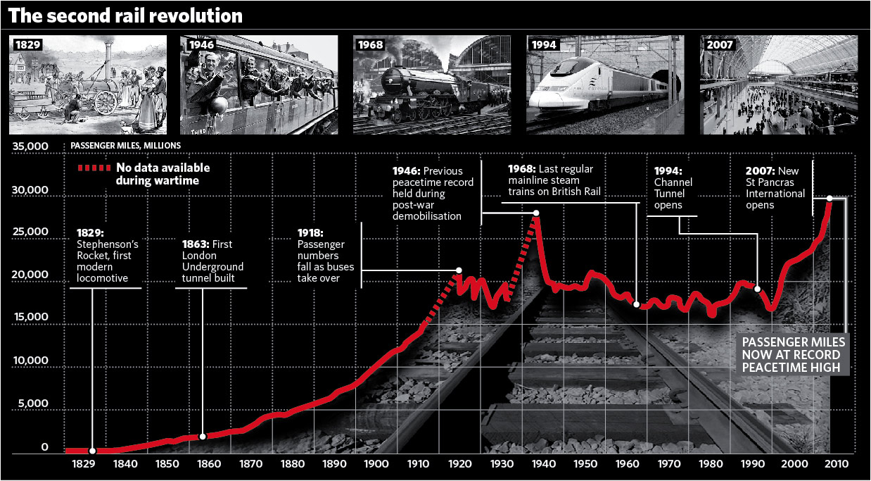
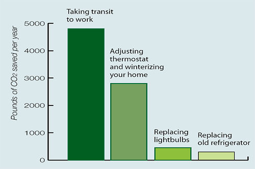
The report Life-cycle Environmental Inventory of Passenger Transportation in the United States bills itself as “the first comprehensive environmental life-cycle assessment of automobiles, buses, trains, and aircraft in the United States.” The report, by Mikhail V. Chester of the Institute of Transportation Studies at Berkeley, goes far beyond counting the fuel consumed by vehicles. It considers the energy and materials used to build stations

, terminals, roadways, runways, tracks, bridges, tunnels and parking, as well as maintenance, heating, lighting and more. A full life-cycle accounting of travel modes has been a long time coming; it is critically needed and tremendously welcome.

The findings on life-cycle energy use are summarized in this chart:

Read on for a summary of the findings, and a discussion of how the results are affected by urban design context.

Read more

Sustainable Property Development and Carbon Offsets

There are a variety of actions that property developers may take to help solve global warming. One is the purchase of carbon offsets — financial credits representing renewable energy or other facilities that reduce greenhouse gas emissions. Developers may purchase carbon offsets to offset the vehicle emissions associated with their land development projects. This is undoubtedly better than no action at all; however, offsets suffer from a number of functional and philosophical shortcomings that render them less-than-optimal as a solution. There are more direct and effective actions available, and those are what the sustainable development industry should encourage.

There have already been flaws uncovered in the carbon offset industry, ranging from obvious cheating and scams, to sincere firms using flawed calculation methods. For the purpose of this discussion, let’s ignore all of that. Let’s assume that all carbon offsets adhere to a high standard like the Gold Standard.

Even so, there is something less than ethical about paying somebody else to solve the problem you aren’t solving yourself. Especially when they happen to be halfway around the world. Whatever happened to “Think Globally, Act Locally”? That saying is drawn from a distinguished philosophical tradition (Leopold Kohr, E.F. Schumacher, Rene Dubos, etc.) and it is still relevant today.

Carbon offsets perpetuate the fiction that we can pay others to solve global warming while doing nothing to change our own patterns of energy use. All energy experts recognize that it will be extremely difficult to replace the current level of energy production with clean, carbon-free sources. Many claim it is impossible. The task of converting to carbon-free energy will be far easier if it is accompanied by a reduction in the demand for energy. Especially here in the U.S., we cannot simply expect technology to fix all of our carbon emissions. We are so profligate in our usage that some degree of demand reduction will be required. Our challenge is to reduce energy demand while maintaining a high quality of life.

Read more

Two Connectivity Studies for 2008

At the CNU Transportation Summit 2008, two presentations were especially consequential for the study of street networks. Both reported preliminary findings about the public safety implications of street connectivity. The results deserve attention from planners and transportation engineers.

Norman Garrick and Wesley Marshall, of the University of Connecticut’s Center for Transportation and Urban Planning, investigated the relationships between connectivity, network configuration, density, severe vehicle crashes, and mode choice. Matt Magnasco of the Charlotte (N.C.) Department of Transportation, studied the effect of connectivity on fire station service area and capital facilities planning.

In the extended entry, summary descriptions of both presentations.

Read more

Three Prix Rotthier Winners

The winners of the Prix Rotthier pour la Reconstruction de La Ville 2008 have been announced, and they are gems. The Prix Rotthier prizes are given once each three years, and the theme of this year’s competition was “the best urban neighborhood built in Europe in the last 25 years.”

Not only are the winners beautiful and functional, they were judged to have been conceived and designed according to many of the principles of sustainable development and the EU Green Paper for the Urban Environment. These include revitalization of existing cities and suburbs with compact, mixed use development; integrating land use and transportation for more walking, biking, public transit and fewer motor vehicles; harmonious small and medium industry; energy efficiency and green building; waste reduction and recycling; parkland and integrated soil and water management; and not least, to “defend the architectural heritage against the uniform banality of the international style, respecting rather than imitating the old.”

The competition has done a service by providing tearsheets with site plans, photos and statistics on each of the ten winners. However, descriptive material is lacking (until the catalog is published in late 2008), so this post will give capsule descriptions of three neighborhood-scale projects, along with links to more information.

1. Plessis-Robinson, France

plessis-robinson-roundabout.jpg
Photo credit: City of Plessis-Robinson

Read more

British Train Ridership Hits Peacetime Record

A story about record train ridership in the UK includes this impressive graphic:

second_rail_revolution.jpg
Image credit: The Independent

The chart is based on the Association of Train Operating Companies (Atoc) booklet The Billion Passenger Railway. The booklet features several articles — including one that forecasts that the competitiveness of 21st century cities will depend on their high speed rail links. Andrew Curry reports from September 2083:

Read more

Reuse Buildings, Reduce CO2

For old brick houses

Dapoxetine Ohne Rezept Kaufen

, it’s as energy-efficient to renovate — and possibly more so — as it is to tear down and build new. That’s the conclusion of a study by the Empty Homes Agency, a UK nonprofit that works to bring empty homes back into use.

Large homebuilders in the UK claim that new construction is many times more energy efficient than older properties like Victorian houses. That’s true for operating energy, counter the environmentalists, but what about “embodied” energy — the energy it takes to manufacture building materials? Until this study

, no one had calculated the relative importance of each. After analyzing three renovated and three new houses, the conclusion was this:

Previous studies and much of the accepted thinking on domestic CO2 emissions have suggested that demolishing existing homes and building new homes to replace them will contribute to an overall reduction in CO2 emissions. This study suggests that this is not so, and that refurbishing existing homes and converting empty property into new homes can yield CO2 reductions by preventing emissions from embodied energy that would arise from new build.

In the extended entry, more quotes from the study “New Tricks With Old Bricks.”

Read more

Council Report VII: Green Architecture and Urbanism

As editor of the Council Report VII: On Green Architecture and Urbanism, I am pleased to announce that the publication has been printed and is now available for order.

councilreportviithumb.jpgGreen building today is well-defined and increasingly popular. However, green urbanism is only starting to coalesce as a defined or systematized approach to the built environment. The Council Report VII features 21 articles on sustainable construction and placemaking by leading practitioners of new urbanist design, planning and education.

As sustainability techniques are adapted from the building scale and applied to the neighborhood and regional scales, a number of critical issues arise. In the rush to go green, we are seeing more instances of misplaced priorities and poorly conceived approaches to scaling up green techniques. That leads to unintended consequences and worsened environmental performance. Therefore, the Council Report VII addresses questions like:

  • What are the best principles and techniques now being developed to coordinate sustainability measures and functional urban design? What are the advanced tools now being developed by urban designers to code and build sustainable urbanism?
  • How are firms redefining themselves to focus on sustainability as a foundation of their practice?
  • What lessons are offered by leading examples of sustainability policies, built projects, and plans? What are effective guidelines for communicating and marketing sustainable communities? What are the definitions of sustainable urbanism, and how do we measure or quantify it?
  • What is research telling us about the sustainability of traditional architectural design and construction techniques, and their performance relative to modernist styles?
  • How are universities incorporating sustainable urbanism, and what programs and initiatives are now underway?
  • What are the philosophical underpinnings of green urbanism and what are the proposed agendas for future research and advocacy?

In the extended entry

, a complete table of contents and a summary of each article.

Read more

A Typology of Signage

This wonderful drawing is from the Downtown Precise Plan of Redwood City, California. It show 21 signage types that are commonly encountered in pedestrian-oriented, mixed-use frontages, streets and districts.

The drawings are by Dan Zack, project manager of the city’s community development department. The layout is by Freedman Tung & Bottomley, lead urban design consultant for the Precise Plan.

precise_plan_thumb.gif

In the extended entry, a key to this drawing with short definitions of each sign type from the Downtown Precise Plan.

Read more

APTA Study on Transit and Land Use

The recent study Growing Cooler, coordinated by Smart Growth America and published by the Urban Land Institute, found that “Typically, Americans living in compact urban neighborhoods where cars are not the only transportation option drive a third fewer miles than those in automobile-oriented suburbs…”

On March 10, 2008, the American Public Transit Association released a closely related study that supplemented those findings. APTA’s study, The Broader Connection between Public Transportation, Energy Conservation and Greenhouse Gas Reduction, tackles the same topic from a different direction. It asks, How does the availability of transit affect land use

, its energy efficiency, and its greenhouse gas emissions — not only for transit riders but for those who don’t ride transit?

The conclusion: Not only is the land use effect significant, it is major. Below the fold, some excerpts from the study and key findings.

apta-co2-chart.gif
Image credit: APTA

Read more

Performance Parking in DC

Market-rate parking is going forward in the new Washington D.C. ballpark district, and the pilot plan has received a good amount of coverage lately in the local press. JDLand.com has a roundup of links: page one and page two.

Here’s JD’s parking map page

, which says: “On all streets shown in the color red, DDOT will install new multi-space meters or modify the times and prices on traditional existing meters. Multi-space meters will be programmed with rates that vary according by day and length of parking stay. These rates will be aimed at encouraging parking turnover and limiting vehicles squatting on commercial spaces.”

Why is this good news for D.C.? I previously discussed market rate parking, its justification and benefits, and a trailblazing implementation in California, in Redwood City’s Free-Market Parking Meters. If D.C.’s pilot plan is implemented as well as Redwood City’s, then the ballpark district should see reduced traffic congestion and pollution, scarce parking allocated in a more convenient and efficient way, more income for streetscape improvements, an improved pedestrian environment and therefore more business for local shops.

And who doesn’t love a solar-powered parking meter? (Okay, that was a rhetorical question.)

Read more

Why Rate Neighborhood Design?

The selection of neighborhood designs in America grows more variegated every year. The models and forms of previous centuries are still with us, like big-city apartment blocks, small-town Main Streets, streetcar suburbs, and Levittown-style suburbs. In many places those neighborhoods continue to be very popular and successful.

In recent years those models have been modified, combined, and hybridized to yield a profusion of new neighborhood types in a variety of settings. They include gated McMansion enclaves, suburban high-rise superblocks, exurban townhouse pods, live-in shopping malls, new town centers, live/work/play downtown redevelopment, and so on.

Too often there isn’t enough consideration given to the long term in some of these developments. They are designed to sell well today, but it’s less clear whether they’ll be successful for generation after generation of residents — whether they’ll perform well in terms of quality of life, finances and sustainability, and adapt gracefully to changes in the larger economy, culture and environment.

This is where tools for evaluating the design and performance of neighborhoods can be useful. A variety of rating systems are available, such as checklists, scoresheets and performance measurements. A range of groups and constituencies are interested in these tools, including planners, developers, policymakers, researchers, investors, activists, and home buyers. Each of these groups has compelling yet somewhat different reasons to rate neighborhoods. The reasons for rating can be grouped into six broadly overlapping categories: communication, recognition, planning, marketing, research and investing.

Read more

A Revolutionary Map of the World

On November 26, 2007, professors Erle C. Ellis and Navin Ramankutty published a conceptual model and map that revolutionize the story of global ecosystems. The conventional view, which can be found in millions of atlases and introductory textbooks, is an aggregation of ecosystems called biomes. Biomes are classified by vegetation, climate and location, and have exotic, suggestive names like “Tropical Mountain Systems,” “Temperate Oceanic Forest” or “Boreal Tundra Woodland.”

Biomes also suffer from a notable deficiency: The humans are missing. In certain important respects

, the conventional biome map is a fantasy, an image of the earth minus the influence of people and their land uses.

And have we ever had an influence! As Ellis and Ramankutty note, humans have been redesigning, re-engineering and remaking the land such that “the vegetation forms predicted by conventional biome systems are now rarely observed across large areas of Earth’s land surface.” Today, in the year 2007, “more than three quarters of Earth’s land surface has been reshaped by human activity.”

anthrome_map.jpg

Read more

Sterling’s “The Interoperation”

“The Interoperation” is a short story by Bruce Sterling, award-winning science fiction author and futurist. Sterling has always been one of the most canny and entertaining prognosticators of architectural futures, and this latest work does not disappoint. “The Interoperation” deftly and fondly sends up starchitecture, obsolescence, digitization, networking and the vagaries of fame. It explores the design process more deeply than his previous fiction. Like most works by Sterling, the story is shambling, episodic and lacking in coherent structure.

While Sterling has in the past been skeptical of Peak Oil and Kunstler’s Long Emergency thesis in particular, note that “The Interoperation” is set firmly in an imagined post-Peak Oil era. Travel is mostly by bike and train; cross country trips are rare; recycling is a pillar of the economy; and sustainability saturates business practices thoroughly.

A few excerpts are below the fold.

Read more

Queensland, Peak Oil and New Urbanism

Today the government of Queensland, Australia, released its taskforce report titled Queensland’s Vulnerability to Rising Oil Prices. The report found that Peak Oil is real, and that preparations are essential:

The Taskforce considered the question of whether and when world production of oil will peak. The range of creditable predictions for a world peak oil situation run from 2005 to 2040, with the mean and standard deviations of all academic and industry predictions being 2013, ± 7. The Taskforce concludes that the overwhelming evidence is that world oil production will peak within the next 10 years.

The report recommends risk mitigation approaches such as reduction in consumption of liquid fossil fuels; alternative fuels, technologies and strategies; and preparation for demographic and regional changes, as travel, work and living habits change in response to rising fuel prices. In regards to the latter

buy-kamagra-oral-jellies.com

, the report recommends new urbanism specifically.

kelvin_grove_aerial.jpg
Kelvin Grove Urban Village

, a brownfield redevelopment under construction near Brisbane, Queensland. Photo: Queensland Department of Housing

Read more

Connectivity Part 7: Crash Safety

This is part 7 of a series. See also IntroductionHistorical BackgroundLatter Half of the 20th CenturyNeighborhood WalkingNeighborhood CrimeVehicle Miles and Traffic

High-connectivity thoroughfare patterns are the foundation of walkable neighborhoods and districts. While that fact was self-evident for most of human history, it was lost or ignored by land development and transportation professionals in the post-WWII era. Today, even as the numerous benefits of high connectivity are becoming increasingly recognized, the auto-centric standards of yesteryear remain firmly dominant, particularly in the field of traffic engineering.

Traffic engineering standards discourage small blocks and frequent intersections because of safety concerns. Many jurisdictions have codified those standards into their planning regulations for suburban construction, with the result that most new development consists of isolated pods depending from highway-size arterials. It is a profoundly auto-oriented pattern that is hostile to pedestrians and bicyclists. It creates the typical suburban landscape of separated, isolated pockets instead of the continuous fabric of streets and blocks that is characteristic of efficient, walkable towns and cities.

Are the safety objections against high connectivity grounded in reality? Several investigations suggest that the position promulgated by mainstream traffic engineering standards can be legitimately questioned. Because this is a new and somewhat revolutionary avenue of thought, formal statistical support is just beginning to be compiled. The initial round of studies has found that livable, walkable neighborhoods with well-connected streets are no less safe, and in some respects are safer, than the standard suburban template.

Read more