Download a print version of this essay.
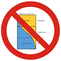 Every field has its foundational working concepts and the field of traffic engineering is no exception. It has a concept called functional classification, which is the core, guiding idea underlying the roadway system of the United States and many other nations. Functional classification is the conceptual foundation of the auto-dependent built environments where most Americans live.
The primary vision of functional classification is moving more and more cars at faster and faster speeds. This has certain benefits, but also a wide range of disastrous consequences for the built environment and the people who live in it. Hundreds, possibly thousands of reform-minded transportation planners and engineers have determined that the roadway functional classification system should be replaced.
It should be replaced by guiding concepts that support a more efficient, safer, less-polluting transportation system – concepts that support a wider range of choices for neighborhood living and daily travel. What factors should be considered when formulating a sustainable transportation system? What proposals have already been made?
Part One of this essay explores those questions. Part Two continues by proposing a replacement, a sustainable transportation network classification, covering the block-scale and neighborhood-scale relationships. Part Three concludes by covering the city-scale relationship and the congestion-related impacts of a sustainable network.
The functional classification system
Functional classification came into practice in the 1920s and 30s, and it was codified into official recommendations in the 1960s and 70s. It is the core concept that informs traffic engineers and planners what types of roads to build and how they ought to connect.
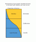
“Mobility” generally means travel speed. “Land access” means the frequency of intersections and driveways on a stretch of thoroughfare. The relationship shown by the diagram is: As mobility increases, land access decreases.
In practice, functional classification results in three rigid postulates:
- The longer the trip, the bigger the roadway
- The bigger the roadway, the faster its traffic should travel
- The faster the traffic on the roadway, the more isolated the roadway must be from its surroundings
The effect on transportation in America is obvious and immense: The large majority of traffic in urban areas is channeled into freeways and arterials.
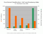
Vehicle miles traveled compared to miles of roadway. Most vehicle travel is channeled on to a relatively small number of highways and arterials. Chart by Laurence Aurbach, based on 2006 FHWA Highway Statistics.
Instead of protecting people from high-volume, high-speed roads, functional classification channels traffic into those roads. They run everywhere, especially the places where most Americans live, work and play. Functional classification creates disconnected, dendritic (tree-like) thoroughfare patterns. It is the underlying foundation of anti-urban, car-dependent landscapes that are so familiar in the suburbs and exurbs of U.S. metro areas.

Schematic of functional classification and neighborhood layout. Image credit: Snohomish County Transportation Authority.
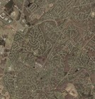
Functional classification realized on the land in Chantilly, Virginia. Photo credit: USGS.
Functional classification has been criticized by numerous commentators (Greenberg and Dock, 2003). Among the criticisms: There is no recognition that thoroughfares have a transportation function and a place function; a severely reduced and oversimplified choice of thoroughfare types; no concern for pedestrians; and no concern for the environmental quality of streets and their contexts. Roadway design is determined by demand/capacity formulas, which dictate that roadways become endlessly wider as population increases. The negative economic, social and environmental consequences include more miles driven every day in cars, more congestion, more crashes, more pollution, more suburban sprawl and less walking (Aurbach 2006, 2007; Hall 2003; Jabobs 2003; Kulash 1996; LaPlante 2007; Scheer 2005).
Note: For the purposes of this essay, a thoroughfare is defined as any transportation facility that carries motor vehicle traffic from place to place. It includes all sizes of facilities, from lanes and alleys to streets, avenues and boulevards.
Note (for traffic planners): Limits on driveways and curb cuts on busy streets are a very effective and important part of safe street design. This essay’s criticisms of the land access aspect of functional classification are only directed at intersection spacing standards. Other techniques of access management that can maintain a high level of connectivity and small, walkable blocks are recommended. See Connectivity Part 7: Crash Safety.
Seemed Like a Good Idea at the Time
For all its limitations, negative impacts and ill-considered consequences, functional classification is based on a logical, sensible idea. It is a rule of thumb that originated during the 1920s and 30s, a time when rail was the primary means of inter-neighborhood and citywide transportation in the U.S. It is derived from the arrangement and operation of urban rail transit:
Update (added 06 November 2014): Functional classification was not conceived as a reflection of rail operations. It developed piecemeal over a period of decades with little or no reference to the rail precedent. The similarity to rail operations is merely an illustrative analogy.
- Local service by trolley was slow (barely more than bicycling speed). Stops were frequent (a stop every block or two). Trains were small (one car).
- Intermediate-scale commuter rail was faster. It covered longer distances between stops (one stop per neighborhood). Larger trainsets were more common (several cars).
- Regional-scale travel had the fastest sustained speeds and the longest distances between stops (one stop per town or village). At first it was served by heavy trains (largest trainsets, multiple cars), later filling in with interurban streetcar service (one or two cars).
In summary: The farther the service, the faster the operating speed and the less frequent the stops.
All of these rail networks operated in walkable places. Whatever the characteristics of urban rail trips — no matter whether they were long or short, fast or slow — they always served pedestrians. Pedestrians boarded from walkable places at trip origins and pedestrians disembarked to walkable places at trip destinations. Urban trains operated in the context of small blocks, well-connected street networks, and mixed land uses in close walking proximity. Walking took place in streets, i.e., travel ways lined with buildings that spatially defined a continuous, linear civic realm.
World War I devastation and the mass production of automobiles started to change all of that. In 1920s Europe, anti-urbanist designers proposed an idea of astonishing hubris: to turn the urban transportation relationship inside out. The trip distance/speed/stop frequency relationship would be applied to car traffic, but with a critical difference. No longer would transportation operate in the context of the walkable city. Instead, the city would be remade to serve the transportation mode. The concept of the street as it had been known for millennia was exploded and discarded; walking would no longer serve as a utilitarian travel mode.
The present idea of the street must be abolished: DEATH OF THE STREET! DEATH OF THE STREET!
– Le Corbusier, The Radiant City (1933), p. 124
Meanwhile in the U.S. a pitched battle for control of urban streets was underway. Today we assume that automobile domination was the uncontroversial result of mass auto ownership. But until the 1920s, every street in America was a “shared space” street, where all pedestrians had the right to use the roadway at any time or at any place they desired. Many, including police, safety officers and traffic engineers, fought to keep it that way by strictly limiting autos to nonlethal speeds. The opposition — auto, oil and road-building industries — spearheaded a movement to ban pedestrians and dedicate streets to ever-faster motor vehicle traffic. Norton (2008) recounts this forgotten history:
Today we tend to regard streets as motor thoroughfares, and we tend to project this construction back to pre-automotive streets. In retrospect, therefore, the use of streets for children’s play (for example) can seem obviously wrong, and thus the departure of children from streets with the arrival of automobiles can seem an obvious and simple necessity. Only when we can see the prevailing social construction of the street from the perspective of its own time can we also see the car as the intruder. Until we do, not only will we fail to understand the violent revolution in street use circa 1915-1930, we will not even see it. This is why the full scale of the wave of blood, grief, and anger in American city streets in the 1920s has eluded notice.
– Peter D. Norton, Fighting Traffic, p. 2
Where did the anti-urbanists go wrong? By destroying the prevailing idea of the city and the street, they turned away from a model that had proven its efficiency and worth over five millennia — and continues to perform well, in thousands of places, for millions of people worldwide. They replaced it with an anti-urban experiment that didn’t work in many ways. They did not foresee (or did not care about) the drastically negative impacts of the “drive-in utopia,” from destroyed land ecology to increased crash risk, from oil wars to global warming, and not least, the negative health, financial cost and quality-of-life impacts of sprawl.
Therefore, the proposed replacement for functional classification is a sustainable network classification that supports sustainable cities. The sustainable city is a walkable city.
Sustainable transport
The most popular definition of sustainability comes from the Brundtland Commission: “Sustainable development is development that meets the needs of the present without compromising the ability of future generations to meet their own needs.” A commonly-used framework is the Three Pillars of social, environmental, and economic sustainability. For transit applications, this framework was agreed to in the “Toronto Protocol” at the 1999 UITP World Congress in Toronto. UITP (2004) has a fine introduction to the topic.
A sampling of indices that may be used to evaluate the sustainability of transportation include:
Environmental – Energy consumption, resource use in land and raw materials per capita (ecological footprint), emissions and pollution per capita as well as regionally and globally. Land impacts (species habitat, nonpoint runoff, watershed degradation, heat island effect).
Social – Access to jobs, retail, services, leisure, religious and civic uses. Comfort, convenience and crash risk. Environmental justice. Access to scenic / recreational land. Loss of prime and local agricultural land. Potential disruptions due to Peak Oil and other energy shortages; strategic dependence on hostile foreign nations. Societal disruptions and security threats resulting from global warming.
Economic – Energy efficiency
, costs of vehicle ownership, operation and maintenance. Location efficiency. Costs of crashes, costs of congestion, cost-benefit analysis, environmental externalities. Subsidies in all forms including parking. Municipal, county, state and federal outlays (school buses, mail service, utilities, paving, emergency services, etc.).
Meta-properties of thoroughfare classification systems
In addition to content, the organization and presentation of a thoroughfare classification system is important. It affects how the system is explained and understood, and what aspects are prioritized. That in turn affects how the system is put into practice.
The functional classification system and alternative systems are built around one or more primary relationships. For instance
, the primary relationship of functional classification is mobility to land access. This makes the system easy to remember and encodes the entire thing in a single diagram. Primary relationships are supplemented with secondary relationships and principles that furnish supplementary conditions, rules of thumb, modifications, subtleties and so forth. A primary relationship has signifying power, because implied within it is a design and engineering outline for an entire physical landscape.
The great strength and great flaw of functional classification is its simplicity. It is reductive in the extreme, dumbing down 5,000 years of rich urban complexity and variety to just a handful of road types and relationships. Sustainable networks necessarily are more complex, because they include a wider variety of factors interoperating on multiple layers and scales.
Unraveling the reductive and tightly-knotted relationships in functional classification will involve a) decoupling speed from trip length; b) decoupling capacity from trip length; and c) decoupling capacity from land access.
Existing Examples
ARTISTS
The Arterial Streets Towards Sustainability (ARTISTS) project was an EU-sponsored initiative completed in 2004. It proposed a new functional classification system that recognizes all users and uses of streets, not just vehicular movement. A supporting research paper, A First Theoretical Approach to Classification of Arterial Streets (Marshall 2002) is required background reading for anyone concerned with thoroughfare classification systems. It is a comprehensive review of all thoroughfare classification systems that have been imagined or implemented.
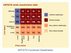
ARTISTS classification matrix. Credit: ARTISTS.
The ARTISTS classification has two axes, link status and place status. Each axis is keyed to the same geographical scale. Link status is the relative significance of a street section as a link in the network, based on its geographical scale. Routes of national significance have more status than routes of city significance, and so on. Routes of local significance have the least status.
Place status is the relative significance of a street section as an urban place, based on its geographical significance and specialization of its land uses. Places of national significance have more importance than places of city significance, and so on.
The ARTISTS system begins with the proposition that people, not vehicles, should be put first in consideration of street design. However, the system’s primary relationship is mostly concerned with accommodating all types of thoroughfares — both people-oriented and traffic-oriented. It provides no guidance about what is the most sustainable or desirable balance, leaving that determination to the political process. In the ARTISTS system, considering people before vehicles, and considering modes of travel other than private vehicles, are secondary relationships.
Advantages: The advantages of the ARTISTS system are several. It recognizes that thoroughfares are places in and of themselves. It puts links and places on an equal footing. It is an extension of existing classification systems, and a system that includes all options may have a better chance of being accepted by the engineering profession. It creates equal roles for engineers (specifying road function) and planners (specifying place function). By recognizing the political aspect of design, it justifies greater public participation.
Disadvantages: A major disadvantage of ARTISTS is that it does little to encourage sustainable thoroughfares. There is little mention of connectivity, efficiency, compact development, context or walkability. It elevates the status of national and citywide routes, which could perpetuate a focus on long-distance commuting instead of in-town development that minimizes vehicle-miles traveled. Local places have the least status, which means they lose in the battle between traffic and place. That may not be in the best interests of neighborhood residents.
In the U.S., the most likely outcome of the ARTISTS approach is a continuation of the status quo. In the U.S., many professional organizations and guidebooks give lip service to sustainable transportation, flexibility in design, consideration of context and all users, and so on – but the vast majority of facilities being planned and built are totally auto-oriented. If we want a system that gives stronger support to sustainable networks, we must look elsewhere.
As Lucy Gibson of Smart Mobility put it, “We need to think more about the goals of how much traffic we want on the street, rather than what the model says we have to accommodate on the street.”
Manual for Streets
The Manual for Streets was released in the UK in 2007. It is a government document that provides technical guidance for the design of livable, walkable streets such as residential and mixed-use streets. It employs a slightly modified version of the ARTISTS primary relationship, supplemented with a full book’s worth of secondary principles.

Manual for Streets primary relationship. Image credit: UK Department of Transport
Here, place status is the relative significance of a thoroughfare “in human terms,” considering especially local distinctiveness, visual quality and ability to encourage social activity. Movement status is a combination of traffic capacity (volume) and geographical scale of destinations served.
The Manual for Streets recommends the flexible application of a user hierarchy, in which pedestrians are considered first, then cyclists, public transport users, service vehicles, and lastly, other motor traffic. It recommends well-connected street networks, design in harmony with local context, and a full range of pedestrian-oriented design strategies for placemaking. It also recommends considering patterns of movement, and how they are affected by the street network pattern.
The Manual for Streets is one of the best comprehensive frameworks for transportation networks. It relies on general principles and flexible guidelines more than strict specifications and rigid categorization.

Manual for Streets user hierarchy. Image credit: UK Department of Transport

Manual for Streets pedestrian and bicycle planning guidance. Image credit: UK Department of Transport
Advantages: Compared to ARTISTS, the definition of place status is more objective and results-oriented. The secondary guidance is generalized and flexible; it mentions network properties like connectivity, and furnishes detailed explanations of pedestrian-oriented thoroughfare design.
Disadvantages: Like ARTISTS, the primary relationship is focused on determining a win-lose contest of pedestrians and vehicles. Movement status defines longest routes as having highest status, which may not match actual patterns of demand or neighborhood needs. The format of the descriptive secondary material constitutes an excellent design manual but is too diffuse and qualitative to work as a classification system. It might be improved if its design recommendations could be systematized into an easily-remembered framework.
SmartCode
The rural-to-urban Transect is such a framework. This concept envisions walkable, built environments on a spectrum from least intensively urban to most intensively urban. The idea dates back centuries, but it recently has been systematized by the planning firm Duany Plater-Zyberk & Co. and is the kernel of the free, open-source SmartCode zoning ordinance.
The rural-to-urban spectrum may be divided into Transect zones for ease of administration; for example, there are six zones in the base SmartCode. Each zone is an immersive environment, where the design elements of walkability are coordinated and harmonized according to time-tested principles and local context. Historically derived design principles ensure that streetscapes are safe and attractive for people on foot. Local context ensures that local heritage, preferences and character are reflected in the patterns of development. Some of the main goals are to maximize the convenience and comfort of walking; to make public spaces lively with activity; and to create or support a wide diversity of living environments for a variety of market preferences.

SmartCode table of thoroughfares. Image credit: Duany Plater-Zyberk & Co.
Different thoroughfare types are allocated to various Transect zones. Thoroughfares are defined in terms of number of lanes
, lane width, types of on-street parking, target speed, and other properties. An important aspect of Transect zones is that they usually encompass an area larger than the streetscape of a single thoroughfare – they usually include the surrounding blocks. Thus context is keyed to local neighborhood characteristics.
The classification implied in the SmartCode (but not stated explicitly) is mostly related to roadway vehicle capacity. Therefore the primary relationship of the SmartCode is: vehicular capacity to place context.
Advantages: Systematizes walkable design principles in an easily remembered framework; highlights diversity of built environments and local context. Useful for designers because dimensions are specified but also are intended to be customized. Establishes network connectivity within neighborhoods via maximum block sizes.
Disadvantages: Reinforces the idea that the purpose of wider thoroughfares is faster auto traffic. Does not address priority for transit or bicycle modes. No inter-neighborhood or city-scale guidance for network configuration.
The Transect framework has been incorporated into the manual Context Sensitive Solutions in Designing Major Urban Thoroughfares for Walkable Communities (Institute of Traffic Engineers, 2006). That document supplements functional classification with pedestrian-oriented thoroughfare types organized by Transect zones. The manual has been critiqued (Steuteville, 2007) and a revision is scheduled to be released in mid- to late-2009. Early rumors indicate the revised version will discard functional classification.
Continued in Part Two: a proposed sustainable network classification.

LJ
This is a wonderful description of our current dilemma. The history is succinct and clear; any reader should see the issues and fully understand. Many references and events were new to me and very enlightening.
I will contact you directly with many detailed comments & questions as time permits. However, several general themes come to mind immediately. Your brief assessment of the ARTISTS matrix, the U.K. Streets Manual and SC are right on target. I’ve been lobbying for less emphasis on ADT in each SC update. The focus must swing away from capacity to speed without hesitation.
Since SC is a model Zoning code, it begs for a planning guide that explains the fundamentals of urban design and the subordinate role of transport to serve that design.
We at HPE have also been emphasizing the block, community and regional scales for determining proper context to lead transportation planning decisions. The T-1 to T-6 transect zones are so captivating that higher order context structure is frequently ignored. We will elaborate on this issue at the Atlanta SC next month.
Outstanding, Rick. I’ll look forward to discussing these ideas in more detail with you. You made a few references that some people might not know, so I’ll clarify that HPE is Hall Planning and Engineering, and that the Atlanta SC is one in an ongoing series of workshops on the SmartCode that will take place April 16-18, 2009 in Atlanta, GA.
Pingback: An essay on functional classification of roadways by Laurence Aurbach « UDSU