Author Archives: Laurence Aurbach

Hercules Slideshow

About 30 urban planners, city officials, council members and developers traveled from Chico, CA to visit Hercules Waterfront District in January, 2007. They went there to experience in person the new urban development in the San Francisco suburbs and to gauge its strengths and weaknesses.

A reporter with a Chico newspaper traveled with the group, wrote two articles about the visit, and assembled a slideshow.

As they toured Hercules, officials considered how its lessons might apply to codes and development in Chico. A similar development is being proposed for Chico, as well as a city-wide zoning code that would make construction of such developments much easier.

hercules.jpg
Ground floor shops with residences above in Hercules Waterfront District, CA. Photo: Jenn Klein, Chico Enterprise-Record

Read more

Connectivity Part 4: Neighborhood Walking

This is part 4 of a series. See also IntroductionHistorical BackgroundLatter Half of the 20th CenturyNeighborhood CrimeVehicle Miles and TrafficCrash Safety

A walkable neighborhood isn’t walkable unless it has a well-connected thoroughfare network. A well-connected network, composed of direct, convenient routes, is one of the key ingredients of walkability. Well-connected neighborhoods have a host of advantages for residents and for the greater community.

A large and growing collection of research is finding that street connectivity is associated with more walking

, less driving, greater safety, less crime, better physical fitness, and fewer per capita emissions. This post reviews the research on neighborhood-scale relationships between connectivity and walking.

Connectivity on the neighborhood scale is about connectivity within neighborhoods. It’s about the routes and connections from building to building, from lot to lot, and from block to block. For more about the key ingredients of walkability, see the frequently asked questions page.

Read more

Connectivity Part 3: Latter Half of the 20th Century

This is part 3 of a series. See also IntroductionHistorical BackgroundNeighborhood WalkingNeighborhood CrimeVehicle Miles and TrafficCrash Safety

Disconnected street networks were the default, entrenched pattern of development in post-WWII America. However, by the early 1960s a backlash had arisen in opposition to the conventional planning wisdom. This countermovement snowballed through the 60s and 70s, and by the 1980s the issue had filtered into the architectural profession and scholarly research.

Part II of this series described how disconnected street patterns became ubiquitous in U.S., with the mandate in particular coming from the Federal Housing Administration. By 1941, over 200 cities had instituted subdivision regulations that encouraged disconnected street patterns.

Read more

Style vs. Form

There are as many different opinions about architectural beauty as there are individuals. Compare any two buildings created with completely different philosophies of style. If you selected a group at random and asked which building’s appearance they preferred, you’d get a lively discussion ranging from indifference, to liking both, to passionately preferring one or the other, to hating both.

Many of the building elements that people relate to beauty are also the most transitory. Elements like facade color

, cladding, window treatments, etc. are the easiest things to change. So when Wal-Mart, for instance, wants to show that it’s addressing community concerns about aesthetics and context, they’ll clad their big boxes in styles that reference local heritage in some vague way. Hill Country stone in Austin, rustic trusses in Colorado, Georgian brick in the Mid-Atlantic, etc. But the end result is still a tilt-up, single-story big box in a sea of parking.

In the opinion of many urban designers, the most important architectural factor that supports a pedestrian-friendly street is not the style, but rather the form of the building. That is, the way the building is sited on its lot, the way it meets the sidewalk, its frequency of doorways and windows, and its general shape and mass.

Read more

Colonial-Era Zoning

Whether or not one calls it zoning, the U.S. has had geographic restrictions on polluters since colonial times. The article ‘Knowing’ Industrial Pollution: Nuisance Law and the Power of Tradition in a Time of Rapid Economic Change, 1840-1864 by Christine Meisner Rosen provides a revealing history:

… colonial governments passed ordinances requiring the owners of slaughterhouses and other nuisance business to clean their premises and forbidding them to toss their wastes into adjacent streets

apoteketreceptfritt.com

, street drains, and streams. They also used their police powers to separate the traditional nuisance industries from people living in densely settled parts of towns, villages, and cities by relegating those industries to peripheral locations. To institutionalize the principle of separation, several colonial governments enacted laws that authorized municipal governments to regulate the location of nuisance industries. Elsewhere, colonial and early national town and state governments protected communities against egregious industrial stenches through public nuisance actions, using their police powers to force businesses that violated the norm of separation to shut down and relocate to less densely populated areas.

That was the regulatory response to traditional nuisances like slaughterhouses and tanneries. But when industrial pollution began impacting the quality of urban life, the law could not adapt to rapid change. Judges and juries were blind to the harms caused by new technologies, a blindness that seems to have been rooted in cognitive psychology. Industrial pollution was too new and unfamiliar; judges could not conceive that the impacts were equal to — or worse than — traditional nuisances.

Read more

Streetcars of Eugene

Bus rapid transit service begins in Eugene, Oregon on Sunday, January 14, 2007. The service is called EmX (short for Emerald Express) and it features custom-designed hybrid-electric vehicles, and stops with raised boarding platforms and real time route information. The route will run four miles from downtown Eugene to downtown Springfield with two and a half miles in exclusive bus-only lanes.

eugenebrt.jpg
Photo by Lane Transit District

In honor of the EmX beginning service, here is a transit history poster I made some years ago, titled Streetcars of Eugene 1907-1927. The poster shows the system in 1912, a period when streetcars were used to boost real estate development. That’s why some of the lines ran through empty fields. These days, planners recommend “land use first”: The demand for development and codes that support transit oriented development should be in place before transit lines are built.

Read more

TNDs With Agriculture

Back in the day — back in the late nineteenth and early twentieth centuries — the Garden City concept was actually about gardens. That is, working, productive gardens for every household. Garden City planners said that working gardens supported the health of residents and the environmental and economic sustainability of the town. Fresh produce and fresh flowers were signal images around which the Garden City movement rallied.

But after a few decades, the Garden City label had became more of a marketing term than a literal description. Green spaces were valued for recreation and scenic qualities rather than food production. That remained true of most U.S. suburbs through the next 50 years.

In 1975, Michael Corbett designed Village Homes in Davis, CA, as a model sustainable suburb. The design utilized many complementary strategies, but in particular, Village Homes incorporated gardens and orchards throughout. That was unprecedented for a development of its scale and density.

Today there is once again a rising interest in local food production. And several ambitious Traditional Neighborhood Developments (TND) are recalling the Village Homes model. They combine new urban design principles with a strong focus on, and involvement with, community agriculture.

Read more

Connectivity Part 2: Historical Background

This is part 2 of a series. See also IntroductionLatter Half of the 20th CenturyNeighborhood WalkingNeighborhood CrimeVehicle Miles and TrafficCrash Safety

Before the automobile age, people didn’t think much about connectivity. It was taken for granted that well-connected street networks were the best way to build cities. The routes between buildings had to be as convenient as possible because everyone moved slowly, compared to today’s motorized transport. Most city folk traveled at 2-4 mph (the speed of walking) and even those with vehicles didn’t move much faster than 7-9 mph (the speed of a horse and buggy).

The invention of the automobile changed all that and gushers of oil provided the fuel. Growth of vehicle production was explosive. America went from 8,000 vehicles in 1900 to 9.2 million in 1920 and 23 million in 1930. In 1916, military trucks allowed the French to win the battle of Verdun. It was the first time motorized vehicles were decisive in a large battle. World War I was pivotal in motorizing the U.S. military.

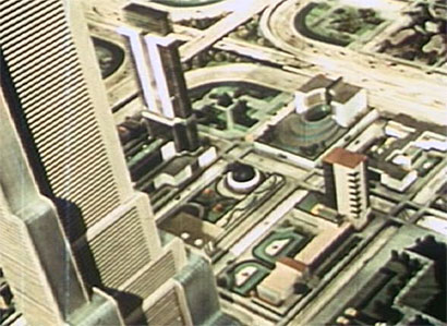
Some architects and planners believed they could transmute the power of mass motor vehicle use into a force for good: a force to alleviate poverty, squalor and oppression of the masses. European modernists like Charles-Edouard “Le Corbusier” Jeanneret and Ludwig Hilberseimer were revolutionaries, fascinated with large-scale schemes that would wipe away the old order and comprehensively reorganize cities for personal mobility via the automobile. The selling points were speed, efficiency, cleanliness and progress, a message that played especially well in America.


Ludwig Hilberseimer, Hochhausstadt, 1924

The American regionalism movement denounced overcrowded, unhealthy cities and the growing threat posed by automobile collisions. As mass ownership of cars and trucks became a reality in the 1920s, the regionalists along with their allies in government, and eventually the real estate industry, began to rethink thoroughfare patterns. Here was something new, they reasoned: door to door service at 30 mph or better! Gradually they concluded that all the old assumptions about connectivity could be tossed aside. Drawing on the Garden City tradition, their solution was a universal pattern of low density cul de sacs set in superblocks.

These initiatives were blows to connected streets in multiple ways. Disconnected street networks became the default pattern throughout the second half of the twentieth century.

Read more

To New Horizons

The 23-minute film To New Horizons is a documentary of the 1939 World’s Fair “Futurama” exhibit. The film and exhibit were commissioned by General Motors to promote a cultural and spatial re-organization of American society that would maximize the corporation’s sales for decades to come.

The opening sequence

antibiotici-acquista.com

, filmed in black and white, is a paean to Progress (with particular attention to the field of highway engineering). Then at minute 7:50, the film switches to Technicolor and begins a tour of the Futurama exhibit — a vision of the futuristic world of 1960. Throughout the film, narration is intoned in a reverent, quasi-religious manner backed by portentous skating-rink theremin music.

futuramablocks.jpg

Read more

The Market for Mixed Use & Walkability

There’s a lot of confusion and skepticism about what Americans really want in a neighborhood. The conventional “American Dream” has, for more than a century, been an house with an acre or so of land in the idyllic suburbs. A lot of Americans still desire that dream — but what percentage, and under what conditions? And will the majority want that dream in the future, or are cultural shifts in the offing? Let’s look at some surveys and projections about the market for neighborhood types.

Current Demand

Several surveys of market preferences have found that a solid majority want large, detached homes, while at the same time there is substantial support for walkability and proximity to mixed use. A 2002 National Association of Homebuilders survey found that a majority wants big, low-cost, spread-out houses, but also that 25 to 35 percent wants destinations within walking distance, sidewalks, workplaces closer to home, and infill in the center city or inner suburbs.

Read more

Macdonald on Street Trees and Intersection Safety

Street trees: valuable neighborhood amenity or safety menace? Many traffic engineers and municipalities take a dim view of arboreal canopies near corners. Now, offering a more positive view, comes Street Trees and Intersection Safety by Elizabeth Macdonald et al. It is probably the most complete investigation of this topic to date, and is nicely readable (for an academic study, that is). Here is some of the opening paragraph:

The study derives from a rather simple, straightforward observation: that on the best tree-lined streets the trees come close to the corners. They do not stop at some distance back from the intersecting street right-of-way. Indeed, in Paris, a city noted for its street trees, if the regular spacing of trees along the street runs short at an intersection, there is likely to be an extra tree placed at the corner. For at least 250 years, the finest of streets the world over have been associated with trees. (p. 7)

The study looks at regulations that have the effect of prohibiting trees on corners, or of stripping street corners bare. Often these regulations are ad hoc and discretionary:

Read more

Connectivity Part 1: Introduction

This is part one of a series. See also Historical BackgroundLatter Half of the 20th CenturyNeighborhood WalkingNeighborhood CrimeVehicle Miles and TrafficCrash Safety

Thoroughfare network connectivity is the single most important element of sustainably-built cities and towns. That may sound like an odd statement, particularly if you’ve never even heard of it. Connectivity has so many interrelated effects on so many urban functions, and more people should recognize how truly essential it is.

Why is connectivity so important? There are many steps to trace, so in this post I’ll start with a definition and overview.

The thoroughfare network is simply the system of arterials, collectors, boulevards, avenues, streets, roads, etc., in an area. Connectivity refers to the directness of travel routes between any two locations, and the number of alternative routes available for traveling between any two locations.

Read more

Is Your NU Too New?

A column by Steven Pearlstein today’s Washington Post business section complains about Reston Town Center. Yes, it’s well designed. Yes, it achieves density without sacrificing the human scale. Yes, it has attracted big-name tenants, and yes, it’s a great financial success. But it’s just “too neat, too homogenized.” It has no liquor stores, no bums or graffiti. It lacks “messy vitality.”

Tysons Corner, says Pearlstein, is more dynamic and real. Yes, it’s one big traffic jam after another. Yes, it’s ugly. But it has “variety, ordered chaos and an urban-like intensity that puts you on edge.” In Mr. Pearlstein’s opinion, it’s a lot like Chicago, Manhattan and San Francisco that way.

Um, I’ve never noticed any bums or graffiti in Tysons Corner either. The only thing dynamic about Tysons’ civic realm is the masses of automobiles gunning from stoplight to stoplight. I agree, it certainly does put you on edge.

Read more

A Brief History of Grid Plans, Ancient to Renaissance

The grid plan dates from antiquity; some of the earliest planned cities were built using grids. This article describes the first historical appearances of grid plans in various parts of the world.

Ancient Grid Plans

By 2600 BC, Mohenjo-daro in the Indus Valley (present-day Pakistan) was built with blocks divided by a grid of straight streets, laid out in perfect right angles, running north-south and east-west. Each block was subdivided by small lanes. Mohenjo-Daro was the largest of many grid-plan towns and villages that existed in the region from 2600-1900 BC.

Obeserving the urban planning of the Indus Valley civilization, archeologist B. B. Lal wrote, “Well-regulated streets [were] oriented almost invariably along with the cardinal directions, thus forming a grid-iron pattern. [At Kalibangan] even the widths of these streets were in a set ratio, i.e. if the narrowest lane was one unit in width, the other streets were twice, thrice and so on.”

Read more